Geolocalizar

Mapa topográfico Montebelluna

Mapa interactivo

Haga clic en el mapa para ver la altitud.

Acerca de este mapa

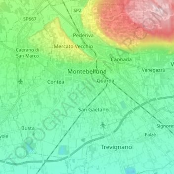
Nombre: Mapa topográfico Montebelluna, altitud, relieve.

Lugar: Montebelluna, Treviso, Veneto, 31044, Italy (45.72298 11.99231 45.81314 12.09770)

Altitud media: 124 m

Altitud mínima: 40 m

Altitud máxima: 369 m

The territory of Montebelluna is largely flat, with altitudes ranging from 69 m a.s.l., found south of San Gaetano, to 144 m, north of Pederiva. The landscape is also characterized by the presence of two hills, including the western end of Montello (where the maximum altitude is, 343 m) and the more modest Capo di Monte (or Montebelluna Alta, or even the hill of Mercato Vecchio, 199 m). Between the two reliefs passes a natural corridor (along which the Feltrina passes), once the original bed of the Piave.

Wikipedia (CC-BY-SA 3.0)

Otros mapas topográficos

Haga clic en un mapa para ver su topografía, su altitud y su relieve.

Resana

Italy > Veneto > Treviso

Resana, Treviso, Veneto, 31023, Italy

Altitud media: 32 m

Brioni

Italy > Veneto > Treviso > San Vito di Altivole

Brioni, San Vito di Altivole, Altivole, Fonte, Treviso, Veneto, 31039, Italy

Altitud media: 83 m

Casale sul Sile

Italy > Veneto > Treviso

Casale sul Sile, Treviso, Veneto, 31032, Italy

Altitud media: 6 m

Istrana

Italy > Veneto > Treviso > Istrana

Istrana, Treviso, Veneto, 31036, Italy

Altitud media: 39 m