
Mapa topográfico Indaiatuba
Mapa interactivo
Haga clic en el mapa para ver la altitud.
Indaiatuba
Indaiatuba es un municipio brasileño del estado de São Paulo. Se localiza a 23º05'25" de latitud sur y 47º13'05" de longitud oeste, a una altitud de 624 metros. Su población oficial en 2011 era de 205.808 habitantes.
Acerca de este mapa
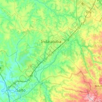
Nombre: Mapa topográfico Indaiatuba, altitud, relieve.
Altitud media: 619 m
Altitud mínima: 497 m
Altitud máxima: 916 m
Otros mapas topográficos
Haga clic en un mapa para ver su topografía, su altitud y su relieve.