Geolocalizar

Mapa topográfico Budapest

Mapa interactivo

Haga clic en el mapa para ver la altitud.

Acerca de este mapa

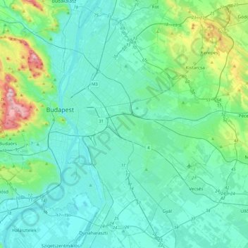
Nombre: Mapa topográfico Budapest, altitud, relieve.

Lugar: Budapest, Hungría Central, Hungría (47.34969 18.92511 47.61315 19.33493)

Altitud media: 171 m

Altitud mínima: 89 m

Altitud máxima: 557 m

Otros mapas topográficos

Haga clic en un mapa para ver su topografía, su altitud y su relieve.

IV. kerület

Hungría > Budapest

IV. kerület, Budapest, Hungría Central, Hungría

Altitud media: 111 m

II. kerület

Hungría > Budapest

II. kerület, Budapest, Hungría Central, Hungría

Altitud media: 252 m

300 m

Hungría > Budapest

300 m, Nagytétény, XXII. kerület, Budapest, Hungría Central, 1224, Hungría

Altitud media: 182 m

VI. kerület

Hungría > Budapest

VI. kerület, Budapest, Hungría Central, Hungría

Altitud media: 114 m

V. kerület

Hungría > Budapest

V. kerület, Budapest, Hungría Central, Hungría

Altitud media: 122 m

Istenhegy

Hungría > Budapest

Istenhegy, 12. kerület, Budapest, Hungría Central, 1125, Hungría

Altitud media: 258 m

Danubio

Hungría > Budapest

Danubio, Budapest, Hungría Central, 1036, Hungría

Altitud media: 114 m