
Mapa topográfico Huamachuco
Mapa interactivo
Haga clic en el mapa para ver la altitud.
Huamachuco
Tierra de los antiguos wachemines y señorío de los Huamachucos, forjadores de cultura, de idioma y de tradición, situada en el corazón del Departamento de La Libertad, a una altitud de 3 169 m s. n. m. y a 184 km de Trujillo, es lugar, donde la continuidad de costumbres ancestrales en danzas, platos típicos y artesanías ofrece un sinnúmero de posibilidades para visitar.
Acerca de este mapa
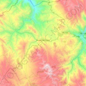
Nombre: Mapa topográfico Huamachuco, altitud, relieve.
Lugar: Huamachuco, Sánchez Carrión, La Libertad, Perú (-7.95735 -78.18765 -7.69427 -77.88111)
Altitud media: 3.359 m
Altitud mínima: 2.231 m
Altitud máxima: 4.720 m
Otros mapas topográficos
Haga clic en un mapa para ver su topografía, su altitud y su relieve.
Laguna Sausacocha
Perú > La Libertad > Huamachuco > Sausacocha
El lago se encuentra a una altitud de 3200 m.s.n.m. y cubre el área aproximada de 4 kilómetros cuadrados (1.5 millas cuadradas) rodeada de colinas bajas. Su profundidad varia entre 1.50 metros en la orilla a 12 - 15 metros en el centro y esto permite la navegación de embarcaciones fluviales pequeñas con…
Altitud media: 3.206 m