
Mapa topográfico Abha
Mapa interactivo
Haga clic en el mapa para ver la altitud.
Abha
Abha (en árabe أبها) es una ciudad saudita en la provincia de Asir, de la que es capital. En 2004 tenía una población de 201 912 habitantes. Está situada a 2 200 metros de altitud, en el suroeste de la península arábiga cerca del parque nacional Asir. El gobierno la ha promocionado como lugar turístico a nivel nacional, dado su clima moderado y la cercanía a espacios naturales.
Acerca de este mapa
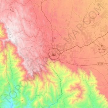
Nombre: Mapa topográfico Abha, altitud, relieve.
Lugar: Abha, محافظة أبها, Provincia de Asir, 26442, Arabia Saudita (18.05643 42.34436 18.37643 42.66436)
Altitud media: 1.994 m
Altitud mínima: 722 m
Altitud máxima: 2.991 m