Geolocalizar

Mapa topográfico Bengaluru

Mapa interactivo

Haga clic en el mapa para ver la altitud.

Acerca de este mapa

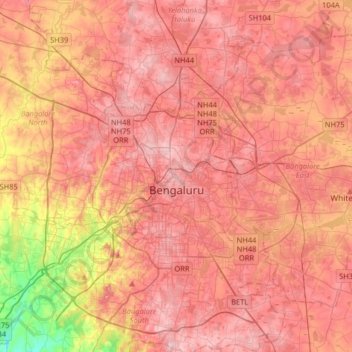
Nombre: Mapa topográfico Bengaluru, altitud, relieve.

Lugar: Bengaluru, Bangalore North, Bengaluru Urban, Karnataka, India (12.83363 77.46005 13.14266 77.78436)

Altitud media: 886 m

Altitud mínima: 731 m

Altitud máxima: 965 m

Bangalore (/ˈbæŋɡəlɔːr, ˌbæŋɡəˈlɔːr/ BANG-gə-lor, -⁠LOR), officially Bengaluru (Kannada pronunciation: [ˈbeŋgɐɭuːɾu] ), is the capital and largest city of the southern Indian state of Karnataka. It has a population of more than 8 million and a metropolitan population of around 15 million, making it India's third most populous city and fourth most populous urban agglomeration. It is the most populous city and largest urban agglomeration in South India, and is the 27th largest city in the world. Located on the Deccan Plateau, at a height of over 900 m (3,000 ft) above sea level, Bangalore has a pleasant climate throughout the year, with its parks and green spaces earning it the reputation of India's "Garden City". Its elevation is the highest of India's major cities.

Wikipedia (CC-BY-SA 3.0)

Otros mapas topográficos

Haga clic en un mapa para ver su topografía, su altitud y su relieve.

Bengaluru

India > Karnataka > Bangalore North > Bengaluru

Bengaluru, Bangalore North, Bangalore Urban, Karnataka, 560001, India

Altitud media: 879 m