
Mapa topográfico Jagual
Mapa interactivo
Haga clic en el mapa para ver la altitud.
Acerca de este mapa
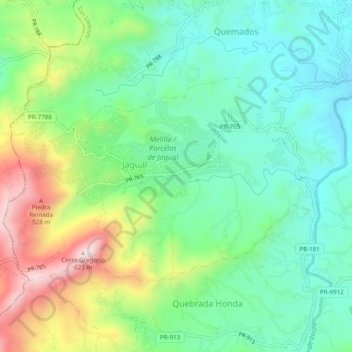
Nombre: Mapa topográfico Jagual, altitud, relieve.
Lugar: Jagual, San Lorenzo, Puerto Rico, United States (18.14539 -66.02316 18.17318 -65.97436)
Altitud media: 260 m
Altitud mínima: 91 m
Altitud máxima: 610 m
Otros mapas topográficos
Haga clic en un mapa para ver su topografía, su altitud y su relieve.
Ponce
United States > Puerto Rico > Ponce
Elevations include Cerro de Punta at 4,390 feet (1,338 m), the highest in Puerto Rico, located in Barrio Anón in the territory of the municipality of Ponce. Mount Jayuya, at 4,314 feet (1,315 m) is located on the boundary between Barrio Anón and Barrio Saliente in Jayuya. Cerro Maravilla, at nearly 3,970…
Altitud media: 189 m
Plaza Santiago Riera Palmer
United States > Puerto Rico > Caguas > Caguas > Sector Viaducto
Altitud media: 72 m
Adjuntas
United States > Puerto Rico > Adjuntas
Adjuntas features a tropical rainforest climate that borders on a subtropical highland climate. While the town technically features a tropical rainforest climate, due to its high elevation, the climate is noticeably cooler than the norm for this climate category. Summers are warm (83°-85 °F) in the daytime…
Altitud media: 688 m
Cerro de Punta
United States > Puerto Rico > Ponce
The mountain is part of the Cordillera Central and is located on the border between the municipalities of Jayuya and Ponce. The access road to the point closest to the highest elevation is from the municipality of Jayuya. It is part of the Toro Negro Forest Reserve, and it has been described as "an alpine…
Altitud media: 1.021 m
Humacao
United States > Puerto Rico > Humacao > Humacao
Humacao is located in the southeast coast of Puerto Rico. It is bordered by the municipalities of Naguabo to the north, Yabucoa to the south, and Las Piedras to the west. The Atlantic Ocean borders the city in the east. Humacao is located in the region of the Eastern Coastal Plains, with most of its territory…
Altitud media: 78 m
Guayama
United States > Puerto Rico > Guayama
The Municipality of Guayama is located on the Southern Coastal Valley region, bordering the Caribbean Sea, south of Cayey; east of Salinas; and west of Patillas and Arroyo. Guayama's municipal territory reaches the central mountain range to the north and the Caribbean Sea to the south. The mountain systems…
Altitud media: 128 m