
Mapa topográfico Nationaal Park De Hoge Veluwe
Mapa interactivo
Haga clic en el mapa para ver la altitud.
Acerca de este mapa
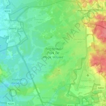
Nombre: Mapa topográfico Nationaal Park De Hoge Veluwe, altitud, relieve.
Altitud media: 41 m
Altitud mínima: 22 m
Altitud máxima: 87 m
Otros mapas topográficos
Haga clic en un mapa para ver su topografía, su altitud y su relieve.
Oud-Reemst
Nederland > Gelderland > Otterlo > Oud-Reemst
Oud-Reemst, Otterlo, Ede, Gelderland, Nederland, 6731, Nederland
Altitud media: 36 m