
Mapa topográfico Morehead
Mapa interactivo
Haga clic en el mapa para ver la altitud.
Acerca de este mapa
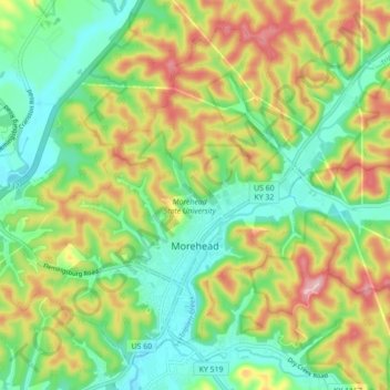
Nombre: Mapa topográfico Morehead, altitud, relieve.
Lugar: Morehead, Rowan County, Kentucky, 40351, United States (38.16309 -83.49611 38.22257 -83.40844)
Altitud media: 287 m
Altitud mínima: 207 m
Altitud máxima: 413 m
Morehead is in the foothills of the Appalachian Mountains. The topography of the area represents a mixture of the Highland Rim and the western border of the Eastern Kentucky Coalfield. The highest elevation in the county is Limestone Knob (1435 ft), situated approximately 3 miles southwest of Morehead. The elevation of the city is 748 ft.