
Mapa topográfico VAM Berg
Mapa interactivo
Haga clic en el mapa para ver la altitud.
Acerca de este mapa
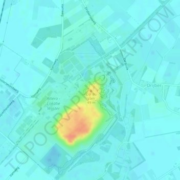
Nombre: Mapa topográfico VAM Berg, altitud, relieve.
Altitud media: 17 m
Altitud mínima: 11 m
Altitud máxima: 51 m
Otros mapas topográficos
Haga clic en un mapa para ver su topografía, su altitud y su relieve.
Spier
Nederland > Drenthe > Midden-Drenthe
Spier, Midden-Drenthe, Drenthe, Nederland
Altitud media: 15 m
Lieving
Nederland > Drenthe > Midden-Drenthe > Lieving
Lieving, Midden-Drenthe, Drenthe, Nederland, 9411, Nederland
Altitud media: 15 m