
Mapa topográfico Ricabo
Mapa interactivo
Haga clic en el mapa para ver la altitud.
Acerca de este mapa
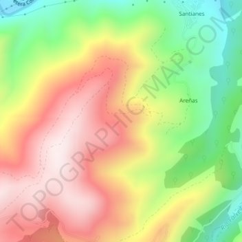
Nombre: Mapa topográfico Ricabo, altitud, relieve.
Lugar: Ricabo, Tineo, Asturias, 33876, España (43.26653 -6.40517 43.28653 -6.38517)
Altitud media: 526 m
Altitud mínima: 216 m
Altitud máxima: 812 m
Otros mapas topográficos
Haga clic en un mapa para ver su topografía, su altitud y su relieve.
Pena el Caleyo
España > Asturias > Tineo > Tineo
Pena el Caleyo, Tineo, Asturias, 33870, España
Altitud media: 855 m