
Mapa topográfico The Arboretum
Mapa interactivo
Haga clic en el mapa para ver la altitud.
Acerca de este mapa
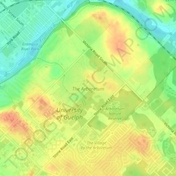
Nombre: Mapa topográfico The Arboretum, altitud, relieve.
Lugar: The Arboretum, Guelph, Southwestern Ontario, Ontario, Canada (43.53299 -80.22264 43.54518 -80.20741)
Altitud media: 332 m
Altitud mínima: 308 m
Altitud máxima: 352 m
Victoria Woods is an old-growth hardwood forest made up of sugar maple, white ash, black cherry and beech. Varied topography in this area, which includes a pond, allows for a wide variety of woodland plants to grow here. Spring is an especially nice time to visit Victoria Woods to see many of these spring ephemeral plants blooming. High moisture content in this woodland's soils make it unsuitable for agriculture, which is a reason why its trees have never been cut.
Otros mapas topográficos
Haga clic en un mapa para ver su topografía, su altitud y su relieve.
John Gamble Park
John Gamble Park, Hanlon Creek, Guelph, Ontario, Canada
Altitud media: 327 m
Silver Creek Conservation Area
Silver Creek Conservation Area, The Ward, Guelph, Southwestern Ontario, Ontario, N1E 3E9, Canada
Altitud media: 326 m