Geolocalizar

Mapa topográfico Bulacan

Haga clic en el mapa para ver la altitud.

Acerca de este mapa

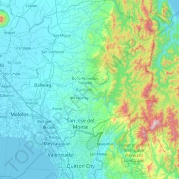
Nombre: Mapa topográfico Bulacan, altitud, relieve.

Lugar: Bulacan, Central Luzon, Philippines (14.60115 120.67670 15.27201 121.34840)

Altitud media: 214 m

Altitud mínima: -2 m

Altitud máxima: 1.505 m

Otros mapas topográficos

Haga clic en un mapa para ver su topografía, su altitud y su relieve.

San Juan

Philippines

"San Juan" is a contraction of the city's traditional name of "San Juan del Monte" (lit. 'Saint John of the Mountain'). As with numerous other places in the Philippines, the name combines a patron saint and a toponym; in this case Saint John the Baptist with the locale's hilly terrain and relatively higher…

Altitud media: 35 m

Malolos

Philippines > Bulacan

Malolos is relatively flat of about 0.81% to a gently sloping of 2.17%. The slope of the land descends towards west, southwest to southern direction. The highest land elevation is at about 6.0 meters above sea level while the lowest is only half a meter below sea level. A network of natural waterways and…

Altitud media: 6 m

Dagupan

Philippines > Pangasinan

Altitud media: 12 m

Zamboanga City

Philippines > Zamboanga Peninsula > Zamboanga City

The overall topography of the city could be described as rolling to very steep. There are some flat lands, mostly narrow strips along the east coast. The urban center is mostly flat with a gentle slope to the interior, ranging from 0 to 3%. The highest registered elevation is 1,200 metres. In terms of slope, a…

Altitud media: 83 m

Garreta

Philippines > Ilocos Norte

Altitud media: 18 m

Agcalaga

Philippines > Iloilo

Altitud media: 151 m

Motiong

Philippines > Samar

Altitud media: 39 m

Namuac

Philippines > Cagayan > Sanchez Mira

Altitud media: 8 m

Pogo Grande

Philippines > Pangasinan > Dagupan

Altitud media: 6 m

Oras

Philippines > Sorsogon > Castilla

Altitud media: 68 m

Panlaitan

Philippines > Palawan > Busuanga

Altitud media: 5 m

Mabuhay

Philippines > Surigao del Sur

Altitud media: 65 m

Talisay Baywalk

Philippines > Batangas > Talisay

Altitud media: 21 m

Legazpi

Philippines > Albay

Legazpi's topography is generally plain on the northeastern areas, with slopes ranging from five to fifteen degrees. The southern areas have mostly rolling to hilly terrain. In the city's coastal areas, the terrain varies from plain (north) to hilly (south). Legazpi is criss-crossed by several rivers including…

Altitud media: 150 m

Tayabas

Philippines > Quezon

Altitud media: 246 m

Santa Rosa

Philippines > Laguna > Santa Rosa

Altitud media: 65 m

Montalban

Philippines > Rizal > Rodriguez

Rodriguez is generally very rough in topography, with 83% of its total land area composed of upland areas, hills and mountain ranges. The remaining 17% low-lying terrain and rolling lands are found at the south-western portion of the municipality, along with the northern portions of the Municipality of San…

Altitud media: 99 m

Sorsogon City

Philippines > Sorsogon

Sorsogon City covers a land area of 31,292 hectares (120.82 sq mi). It is at the southernmost tip of the Bicol Peninsula and of Luzon Island. The city is bounded by Castilla in the west, Manito in the northwest, Albay Gulf in the north, Prieto Diaz in the east, Gubat in the southeast, Casiguran in the…

Altitud media: 89 m

Baguio

Philippines

In 1903, Filipinos, Japanese and Chinese workers were hired to build Kennon Road, the first road directly connecting Baguio with the lowlands of La Union and Pangasinan. Before this, the only road to Benguet was Naguilian Road, and it was largely a horse trail at higher elevations. Camp John Hay was…

Altitud media: 881 m

Cristo Rey

Philippines > Tarlac > Capas

Altitud media: 75 m

Sinangguyan

Philippines > Bukidnon > Don Carlos

Altitud media: 286 m

Biringan

Philippines > Samar > Pagsanghan

Altitud media: 20 m

Cajumpan

Philippines > Samar > Calbayog

Altitud media: 9 m

Cagayan River

Philippines > Isabela > Paragu

Altitud media: 33 m

Iba Este

Philippines > Bulacan > Calumpit

Altitud media: 4 m

General Terrero

Philippines > La Union > Bangar

Altitud media: 7 m

Mount Manabu

Philippines > Laguna > Alaminos

Altitud media: 555 m

Abacan River

Philippines > Angeles > Amsic

Altitud media: 122 m

Buliran

Philippines > Nueva Ecija > San Antonio

Altitud media: 14 m

Maigo

Philippines > Lanao del Norte

Altitud media: 36 m

Rotunda Bucandala

Philippines > Cavite > Imus

Altitud media: 16 m

Iriga

Philippines > Camarines Sur

Altitud media: 115 m

Argao

Philippines > Cebu

Altitud media: 31 m

Itum

Philippines > Bohol > Duero

Altitud media: 69 m

Bacnotan

Philippines > La Union

The topography of the town is characterized by hilly and mountainous terrain rising gradually eastward. The western side of Bacnotan is defined by a long stretch of black sand beaches facing the South China Sea, indicative of the area's abundant magnetite deposits. Certain parts of the coastline also feature…

Altitud media: 21 m

San Fernando

Philippines > La Union

Altitud media: 81 m

Tanay

Philippines > Rizal

Altitud media: 32 m

Valencia

Philippines > Bukidnon

The city's topography is characterized as flat to undulating hills with extensive plateaus and mountainous areas and cliffs on both eastern and western portions bounding the municipality of San Fernando on the east and the municipality of Talakag on the west. Its highest point is Mount Kalatungan in the…

Altitud media: 566 m

Tagaytay

Philippines > Cavite

The southern and eastern portions of Tagaytay are covered by hills and mountains which is generally forests, pine trees and open grasslands. The city lies along Tagaytay Ridge, a ridge stretching about 32 kilometres (20 mi) from Mount Batulao in the west to Mount Sungay in the east with elevations averaging…

Altitud media: 229 m

Cabanatuan

Philippines > Nueva Ecija

Altitud media: 47 m

Tagum

Philippines > Davao del Norte

One of the significant accomplishments of the officialdom of Tagum during the 1990s was its elevation from a second to the first-class municipality. This opened a gateway to increase its financial resources through the Internal Revenue Allocation (IRA) from the national government and local revenues. This was…

Altitud media: 103 m

Mandaluyong

Philippines

Another claims that the Spaniards named the place based on the report of a navigator named Acapulco, who saw the rolling hills frequently being lashed at by daluyong (“big waves from the sea”). This seems to confirm traditional pre-Hispanic stories that giant waves from the sea would meet the adjoining…

Altitud media: 33 m

Cebu City

Philippines > Cebu > Cebu City

Altitud media: 140 m

Quezon City

Philippines

Founded as a pueblo by Saint Pedro Bautista in 1590, San Francisco del Monte may be considered Quezon City's oldest district. The original land area of the old town of San Francisco del Monte was approximately2.5 square kilometres (1.0 sq mi) and covered parts of what is currently known as Project 7 and 8 and…

Altitud media: 57 m

Baucawe

Philippines > Surigao del Sur

Altitud media: 28 m

Hinactacan

Philippines > Iloilo City

Altitud media: 4 m

Balaytigue

Philippines > Batangas > Nasugbu

Altitud media: 23 m

Obi

Philippines > Catanduanes > Caramoran

Altitud media: 222 m

Libas

Philippines > South Cotabato > Tantangan

Altitud media: 73 m

Licsi

Philippines > Pangasinan > Manaoag

Altitud media: 20 m

Taracay

Philippines > Apayao > Lenneng

Altitud media: 350 m

Tabaan Sur

Philippines > Benguet

Altitud media: 676 m

Aw-asen Falls

Philippines > Ilocos Sur

Altitud media: 467 m

Inabasan

Philippines > Iloilo

Altitud media: 120 m

Currimao

Philippines > Ilocos Norte

Altitud media: 13 m

San Juan

Philippines > Bulacan > San Ildefonso

Altitud media: 14 m

Zaldivar

Philippines > Guimaras > Buenavista

Altitud media: 30 m

Daquioag

Philippines > Ilocos Norte

Altitud media: 59 m

Caloocan

Philippines > Caloocan > Caloocan

Altitud media: 19 m

Pasay

Philippines

Altitud media: 14 m

Vigan

Philippines > Ilocos Sur

Vigan is situated in a Quaternary Age sedimentary plain called the Vigan-Bantay Plain which is part of the Ilocos coastal plain. The Vigan-Bantay Plain is bounded on the east by a moderately rugged Miocene sediments consisting of interbedded sandstones and shale to very rugged Meta-volcanics and Meta sediment…

Altitud media: 63 m

Bacolod

Philippines

Bacólod (English: Bacolod), is derived from bakólod (Old Spelling: bacólod), the Old Hiligaynon (Old Ilonggo) (Old Spelling: Ylongo and Ilongo) word for a "hill, turtle, mound, rise, hillock, down, any small eminence or elevation", since the resettlement was founded on a stony, hilly area, now the barangay…

Altitud media: 49 m

Antipolo

Philippines > Rizal

Its higher elevation than that of Metro Manila affords it a scenic view of the metropolis, especially at night. Its locally grown mangoes and cashews are popular among tourists, as well as suman – a local delicacy made out of glutinous rice. The Hinulugang Taktak National Park, which was once a popular…

Altitud media: 125 m

San Fernando

Philippines > Pampanga

Altitud media: 24 m

Gayong

Philippines > Isabela > Cordon

Altitud media: 114 m

Baluntay

Philippines > Sarangani > Alabel

Altitud media: 23 m

Tunasan River

Philippines > Laguna > Muntinlupa

Altitud media: 69 m

Upper Pailob

Philippines > Cebu City

Altitud media: 18 m

Guimpingan

Philippines > Romblon > Romblon

Altitud media: 67 m

Santa Lucia

Philippines > Pampanga > Magalang

Altitud media: 59 m

Dalican

Philippines > Mountain Province

Altitud media: 1.332 m

Manaol

Philippines > Pangasinan

Altitud media: 45 m

Madaum

Philippines > Davao del Norte > Tagum

Altitud media: 9 m

Sumadel

Philippines > Mountain Province

Altitud media: 1.197 m

Mother Falls

Philippines > Aurora

Altitud media: 452 m

Nurcia

Philippines > Surigao del Sur

Altitud media: 95 m

Tampugo

Philippines > Ilocos Sur

Altitud media: 22 m

Kota Island

Philippines

Altitud media: 0 m

Dayawan

Philippines > Misamis Oriental

Altitud media: 120 m

Ogao

Philippines > Sorsogon

Altitud media: 13 m

Burdeos

Philippines > Quezon

Altitud media: 44 m

Batchelor East

Philippines > Pangasinan

Altitud media: 164 m

Paracelis

Philippines > Mountain Province

Altitud media: 305 m

Balamban

Philippines > Cebu

Farming is another source of livelihood for residents with corn, crops and vegetables among the important crops. The municipality is also the only source of abaca fibers in Cebu produced in a 260-to-300-hectare (640-to-740-acre) plantation in Mount Manunggal in barangay Magsaysay. With the elevation of 500…

Altitud media: 28 m

Lote

Philippines > South Cotabato > Tupi

Altitud media: 346 m

Tara

Philippines > Camarines Sur > Sipocot

Altitud media: 35 m

Pulag

Philippines > Benguet

Altitud media: 2.024 m

Masiu

Philippines > Lanao del Sur

Altitud media: 757 m

Samal Island

Philippines > Davao del Norte > Samal

Altitud media: 117 m

Indang

Philippines > Cavite > Indang

The topography of Indang is characterised by gently sloping or rolling terrain. Almost 40.36% of its total land area is within the slope grade of 3-8%, while 2,135 hectares is within the slope range of 8-15% which is characterised by undulating or sloping terrain.

Altitud media: 298 m

Meycauayan

Philippines > Bulacan

Altitud media: 27 m

Iligan

Philippines

Altitud media: 229 m

Equípate para tu próxima aventura:

🧤Guantes de senderismo - Protección térmica y agarre en montaña
🪜Cordinos de seguridad - Apoyo técnico en montaña
📢Silbatos de Emergencia - Házte oír en caso de rescate o pérdida en la montaña
🧴Impermeabilizante para Botas - Spray protector para mantener tus pies secos en cualquier mapa
🥾Botas de senderismo - Botas resistentes y cómodas para rutas de montaña

Como asociado de Amazon, este sitio gana comisiones por las compras que califican, sin ningún costo adicional para usted.