Geolocalizar

Mapa topográfico Bulacan

Mapa interactivo

Haga clic en el mapa para ver la altitud.

Acerca de este mapa

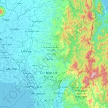
Nombre: Mapa topográfico Bulacan, altitud, relieve.

Lugar: Bulacan, Central Luzon, Philippines (14.60115 120.67670 15.27201 121.34840)

Altitud media: 214 m

Altitud mínima: -2 m

Altitud máxima: 1.505 m

Otros mapas topográficos

Haga clic en un mapa para ver su topografía, su altitud y su relieve.

Quezon City

Philippines

Founded as a pueblo by Saint Pedro Bautista in 1590, San Francisco del Monte may be considered Quezon City's oldest district. The original land area of the old town of San Francisco del Monte was approximately2.5 square kilometres (1.0 sq mi) and covered parts of what is currently known as Project 7 and 8 and…

Altitud media: 57 m

Bacolod

Philippines

Bacólod (English: Bacolod), is derived from bakólod (Old Spelling: bacólod), the Old Hiligaynon (Old Ilonggo) (Old Spelling: Ylongo and Ilongo) word for a "hill, turtle, mound, rise, hillock, down, any small eminence or elevation", since the resettlement was founded on a stony, hilly area, now the barangay…

Altitud media: 49 m

Pasay

Philippines

Altitud media: 14 m

Cebu City

Philippines > Cebu > Cebu City

Altitud media: 140 m

Santa Rosa

Philippines > Laguna > Santa Rosa

Altitud media: 65 m

Malainen Luma

Philippines > Cavite > Naic

Altitud media: 54 m

Zamboanga City

Philippines > Zamboanga Peninsula > Zamboanga City

The overall topography of the city could be described as rolling to very steep. There are some flat lands, mostly narrow strips along the east coast. The urban center is mostly flat with a gentle slope to the interior, ranging from 0 to 3%. The highest registered elevation is 1,200 metres. In terms of slope, a…

Altitud media: 83 m

Tuburan

Philippines > Cebu

Altitud media: 48 m

Naga

Philippines > Cebu

Altitud media: 102 m

Carmen

Philippines > Cebu

Altitud media: 59 m

San Jose de Buan

Philippines > Samar

Altitud media: 299 m

Lumondao

Philippines > Davao City

Altitud media: 488 m

Buenavista

Philippines > Quezon

Altitud media: 66 m

Montay

Philippines > North Cotabato > Libungan

Altitud media: 66 m

Mandaluyong

Philippines

Another claims that the Spaniards named the place based on the report of a navigator named Acapulco, who saw the rolling hills frequently being lashed at by daluyong (“big waves from the sea”). This seems to confirm traditional pre-Hispanic stories that giant waves from the sea would meet the adjoining…

Altitud media: 33 m

Tanay

Philippines > Rizal

Altitud media: 32 m

Caloocan

Philippines > Caloocan > Caloocan

Altitud media: 19 m

Calumpit

Philippines > Bulacan > Calumpit

Altitud media: 4 m

Alfonso

Philippines > Cavite > Alfonso

Altitud media: 413 m

Ilawod

Philippines > Camarines Sur > Caramoan

Altitud media: 64 m

Kuya

Philippines > Bukidnon > Maramag

Altitud media: 682 m

Tunasan River

Philippines > Muntinlupa

Altitud media: 47 m

Tamacan

Philippines > Cavite > Amadeo

Altitud media: 293 m

Nauring

Philippines > Antique > Pandan

Altitud media: 12 m

Bagong Silang

Philippines > Isabela > Ilagan

Altitud media: 56 m

Cuayang Bugtong

Philippines > Pampanga > Candaba

Altitud media: 11 m

Aberawan

Philippines > Palawan > El Nido

Altitud media: 37 m

Energy Park

Philippines > Davao del Norte > Tagum

Altitud media: 18 m

Ramirez

Philippines > Cavite > Magallanes

Altitud media: 190 m

San Martin

Philippines > Bukidnon > Malaybalay

Altitud media: 386 m

Mainit

Philippines > Leyte > Alangalang > Binungto-an

Altitud media: 40 m

San Agustin

Philippines > Cavite > Trece Martires

Altitud media: 110 m

Rizal

Philippines > Quirino > Rizal

Altitud media: 130 m

Dalicanan

Philippines > Iloilo

Altitud media: 131 m

Maislap

Philippines > Rizal > Montalban

Altitud media: 82 m

Townsite

Philippines > Bataan > Limay

Altitud media: 20 m

Patong-patong

Philippines > Iloilo

Altitud media: 106 m

Dugmanon

Philippines > Davao Oriental > San Isidro

Altitud media: 127 m

Bagabag

Philippines > Nueva Vizcaya

Altitud media: 262 m

Gatbuca

Philippines > Bulacan > Calumpit

Altitud media: 5 m

Tagaytay

Philippines > Cavite

The southern and eastern portions of Tagaytay are covered by hills and mountains which is generally forests, pine trees and open grasslands. The city lies along Tagaytay Ridge, a ridge stretching about 32 kilometres (20 mi) from Mount Batulao in the west to Mount Sungay in the east with elevations averaging…

Altitud media: 229 m

Amadeo

Philippines > Cavite > Amadeo

Altitud media: 422 m

Bacoor

Philippines > Cavite

Altitud media: 18 m

Tatawiran

Philippines > Quezon > General Nakar

Altitud media: 617 m

Camarag

Philippines > Isabela

Altitud media: 72 m

Purok 3

Philippines > Samar > Santa Margarita > Burabod

Altitud media: 13 m

San Roque

Philippines > Bulacan > Pandi

Altitud media: 26 m

San Antonio

Philippines > Albay > Tabaco

Altitud media: 73 m

Raradangan

Philippines > North Cotabato > Alamada

Altitud media: 234 m

San Narciso

Philippines > Zambales

San Narciso is located in a relatively flat plain. West of the town is the South China Sea and to the east is bordered by the Sto. Tomas river are the Zambales Mountain Ranges. Average elevation is 3.6 metres (12 ft) above sea level and the highest elevation is 800 metres (2,600 ft) above sea level.

Altitud media: 11 m

San Fernando

Philippines > Pampanga

Altitud media: 24 m

Malolos

Philippines > Bulacan

Malolos is relatively flat of about 0.81% to a gently sloping of 2.17%. The slope of the land descends towards west, southwest to southern direction. The highest land elevation is at about 6.0 meters above sea level while the lowest is only half a meter below sea level. A network of natural waterways and…

Altitud media: 6 m

Punta Tabuc

Philippines > Capiz > Roxas

Altitud media: 5 m

Cainta

Philippines > Rizal

Altitud media: 24 m

Nagas

Philippines > Albay

Altitud media: 32 m

Luciano

Philippines > Cavite > Trece Martires

Altitud media: 126 m

Butig

Philippines > Lanao del Sur

Altitud media: 806 m

Tierra Nevada

Philippines > Camarines Sur

Altitud media: 153 m

Masinloc

Philippines > Zambales

Altitud media: 13 m

Antipolo

Philippines > Rizal

Its higher elevation than that of Metro Manila affords it a scenic view of the metropolis, especially at night. Its locally grown mangoes and cashews are popular among tourists, as well as suman – a local delicacy made out of glutinous rice. The Hinulugang Taktak National Park, which was once a popular…

Altitud media: 125 m

Iligan

Philippines

Altitud media: 229 m

Dan-ar

Philippines > Ilocos Sur

Altitud media: 52 m

Tibolo

Philippines > Davao del Sur > Santa Cruz

Altitud media: 991 m

Amsipit

Philippines > Sarangani > Maasim

Altitud media: 499 m

San Juan

Philippines > Tarlac > Capas

Altitud media: 48 m

Upper Libungan

Philippines > Davao City > Calinan > Lamanan

Altitud media: 273 m

Dalwangan

Philippines > Bukidnon > Malaybalay

Altitud media: 892 m

Tagoloan

Philippines > Misamis Oriental

Altitud media: 22 m

Bantay

Philippines > Ilocos Sur

It has an average elevation of 100 meters (328.08 feet), with a land area of 7,660 hectares (18,900 acres). It is an elevated and hilly municipality but some barangays, especially those near creeks, are prone to flooding during heavy typhoons.

Altitud media: 8 m

Ligaya

Philippines > Occidental Mindoro > Sablayan

Altitud media: 699 m

Kaylaway

Philippines > Batangas > Nasugbu

Altitud media: 431 m

Splash Island

Philippines > Laguna > Biñan

Altitud media: 21 m

Bentung

Philippines > South Cotabato > Polomolok

Altitud media: 335 m

Pagsangahan

Philippines > Catanduanes > San Miguel

Altitud media: 171 m

Montalban

Philippines > Rizal > Rodriguez

Rodriguez is generally very rough in topography, with 83% of its total land area composed of upland areas, hills and mountain ranges. The remaining 17% low-lying terrain and rolling lands are found at the south-western portion of the municipality, along with the northern portions of the Municipality of San…

Altitud media: 99 m

Little Ville

Philippines > Rizal > Tanay

Altitud media: 55 m

Tiguib

Philippines > Cebu > Badian

Altitud media: 316 m

Maslog

Philippines > Eastern Samar

Altitud media: 57 m

Butuan

Philippines

Altitud media: 115 m

San Juan

Philippines

"San Juan" is a contraction of the city's traditional name of "San Juan del Monte" (lit. 'Saint John of the Mountain'). As with numerous other places in the Philippines, the name combines a patron saint and a toponym; in this case Saint John the Baptist with the locale's hilly terrain and relatively higher…

Altitud media: 35 m

Mayuro

Philippines > Batangas > Rosario

Altitud media: 142 m

Manaoag

Philippines > Isabela

Altitud media: 46 m

Samal Island

Philippines > Davao del Norte > Samal

Altitud media: 117 m

Mount Natib

Philippines > Bataan > Morong

Mount Natib is a stratovolcano type of volcano topped by a 6-by-7-kilometre (3.7 by 4.3 mi) acorn-shaped Natib Caldera that is open to the northwest. East of its caldera is the smaller 2-kilometre (1.2 mi) wide Pasukulan Caldera. The highest peak of Mount Natib has an elevation of 1,253 metres (4,111 ft) asl…

Altitud media: 846 m

Jolo

Philippines > Sulu

Altitud media: 57 m

Suyo

Philippines > Ilocos Sur

Altitud media: 259 m

Mataas na Burol

Philippines > Cavite > Silang

Altitud media: 447 m

Tiep

Philippines > Pangasinan

Altitud media: 100 m

Canipa

Philippines > Davao de Oro > Pantukan

Altitud media: 10 m