
Mapa topográfico Gananoque Lake
Mapa interactivo
Haga clic en el mapa para ver la altitud.
Acerca de este mapa
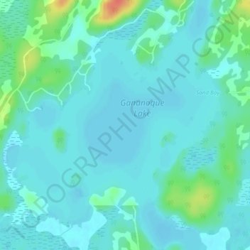
Nombre: Mapa topográfico Gananoque Lake, altitud, relieve.
Altitud media: 90 m
Altitud mínima: 81 m
Altitud máxima: 130 m
Otros mapas topográficos
Haga clic en un mapa para ver su topografía, su altitud y su relieve.
Gananoque River
Canada > Ontario > Leeds and the Thousand Islands > Willowbank
Gananoque River, Turn Around Road, Willowbank, Leeds and the Thousand Islands, Leeds and Grenville Counties, Eastern Ontario, Ontario, K7G 1G4, Canada
Altitud media: 92 m
Southern Water
Canada > Ontario > Leeds and the Thousand Islands > Outlet
Southern Water, Outlet, Leeds and the Thousand Islands, Leeds and Grenville Counties, Eastern Ontario, Ontario, Canada
Altitud media: 93 m
Ivy Lea
Canada > Ontario > Leeds and the Thousand Islands > Ivy Lea
Ivy Lea, Leeds and the Thousand Islands, Leeds and Grenville Counties, Eastern Ontario, Ontario, K0E 1L0, Canada
Altitud media: 87 m
Gananoque Lake
Canada > Ontario > Leeds and the Thousand Islands
Gananoque Lake, Deryaw Road, Leeds and the Thousand Islands, Leeds and Grenville Counties, Eastern Ontario, Ontario, K0H 2N0, Canada
Altitud media: 92 m