
Mapa topográfico Pocahontas County
Mapa interactivo
Haga clic en el mapa para ver la altitud.
Pocahontas County
According to the United States Census Bureau, the county has a total area of 942 square miles (2,440 km2), of which 940 square miles (2,400 km2) is land and 1.5 square miles (3.9 km2) (0.2%) is water. It is the third-largest county in West Virginia by area, and with a mean altitude of 3,219 feet or 981 metres it is the sixth-highest county east of the Mississippi River and the highest county in this region outside Western North Carolina.
Acerca de este mapa
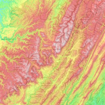
Nombre: Mapa topográfico Pocahontas County, altitud, relieve.
Lugar: Pocahontas County, West Virginia, United States (38.03655 -80.36479 38.73981 -79.61791)
Altitud media: 920 m
Altitud mínima: 327 m
Altitud máxima: 1.476 m
Otros mapas topográficos
Haga clic en un mapa para ver su topografía, su altitud y su relieve.
Mason-Dixon Historical Park
United States > West Virginia > Monongalia County > Holman
Altitud media: 330 m
White Top
United States > West Virginia > Randolph County
White Top is a knob and spur of Cheat Mountain in southeastern Randolph County, West Virginia, USA. Sitting at an elevation of 4,085 feet (1,245 m), it is located just west of the Shavers Fork of Cheat River and Cheat Bridge. While White Top was originally crossed by the Staunton–Parkersburg Turnpike,…
Altitud media: 1.159 m
Spruce Knob
United States > West Virginia > Pendleton County
Spruce Mountain, located in eastern West Virginia, is the highest ridge of the Allegheny Mountains. The whale-backed ridge extends for only 16 miles (26 km) from northeast to southwest, but several of its peaks exceed 4,500 feet (1,400 m) in elevation. The summit, Spruce Knob (4,863 ft; 1,482 m), is the…
Altitud media: 1.274 m
Alderson Recreation Area
United States > West Virginia > Greenbrier County > Alderson
Altitud media: 501 m