
Mapa topográfico Alden Bridge
Mapa interactivo
Haga clic en el mapa para ver la altitud.
Acerca de este mapa
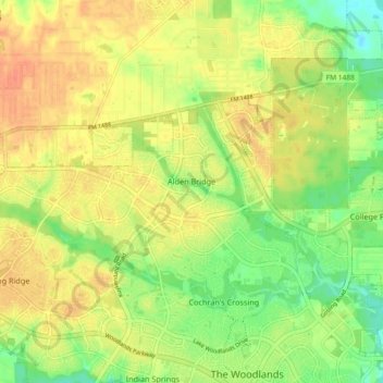
Nombre: Mapa topográfico Alden Bridge, altitud, relieve.
Altitud media: 55 m
Altitud mínima: 32 m
Altitud máxima: 72 m
Otros mapas topográficos
Haga clic en un mapa para ver su topografía, su altitud y su relieve.
Indian Springs
United States > Texas > Montgomery County > The Woodlands
Indian Springs, The Woodlands, Montgomery County, Texas, United States
Altitud media: 48 m
College Park
United States > Texas > Montgomery County > The Woodlands
College Park, The Woodlands, Montgomery County, Texas, United States
Altitud media: 47 m
Grogan's Mill
United States > Texas > Montgomery County > The Woodlands
Grogan's Mill, The Woodlands, Montgomery County, Texas, 77380, United States
Altitud media: 40 m