
Mapa topográfico Bezirk Landeck
Mapa interactivo
Haga clic en el mapa para ver la altitud.
Acerca de este mapa
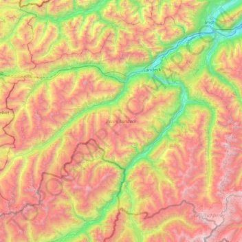
Nombre: Mapa topográfico Bezirk Landeck, altitud, relieve.
Lugar: Bezirk Landeck, Tirol, Austria (46.82251 10.09783 47.25091 10.82162)
Altitud media: 2.061 m
Altitud mínima: 703 m
Altitud máxima: 3.681 m
Otros mapas topográficos
Haga clic en un mapa para ver su topografía, su altitud y su relieve.
Stadt Kitzbühel
Austria > Tirol > Bezirk Kitzbühel
Stadt Kitzbühel, Bezirk Kitzbühel, Tirol, 6370, Austria
Altitud media: 1.176 m
Durach
Austria > Tirol > Bezirk Kitzbühel > Marktgemeinde Hopfgarten im Brixental > Kelchsau
Durach, Kelchsau, Marktgemeinde Hopfgarten im Brixental, Bezirk Kitzbühel, Tirol, 6361, Austria
Altitud media: 1.134 m