
Mapa topográfico Panama City Beach
Mapa interactivo
Haga clic en el mapa para ver la altitud.
Panama City Beach
Panama City Beach, located in Bay County, Florida, features a predominantly flat topography typical of coastal areas. Its terrain is characterized by low elevations, generally ranging between 20 to 30 feet (6 to 9 meters) above sea level. This flatness is interrupted by occasional sand dunes that rise up along the shore, contributing to the region’s scenic beachfront. The city lies along the Gulf of Mexico, with the Gulf Lagoon and St. Andrews Bay nearby, creating a unique environment of sandy stretches and shallow waters. The area’s terrain is ideal for beach activities and is shaped by both natural processes and human development. The land is part of the larger Gulf Coastal Plain, offering expansive views and easy access to water from almost any point in the region.
Acerca de este mapa
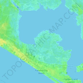
Nombre: Mapa topográfico Panama City Beach, altitud, relieve.
Lugar: Panama City Beach, Bay County, Florida, United States (30.16509 -85.95800 30.29679 -85.78590)
Altitud media: 2 m
Altitud mínima: -2 m
Altitud máxima: 17 m
Otros mapas topográficos
Haga clic en un mapa para ver su topografía, su altitud y su relieve.