
Mapa topográfico Waushara County
Mapa interactivo
Haga clic en el mapa para ver la altitud.
Acerca de este mapa
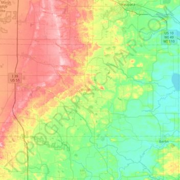
Nombre: Mapa topográfico Waushara County, altitud, relieve.
Lugar: Waushara County, Wisconsin, United States (43.98200 -89.59811 44.24578 -88.88587)
Altitud media: 283 m
Altitud mínima: 225 m
Altitud máxima: 394 m
Otros mapas topográficos
Haga clic en un mapa para ver su topografía, su altitud y su relieve.
Madison
United States > Wisconsin > Dane County
The city is sometimes described as The City of Four Lakes, comprising the four successive lakes of the Yahara River: Lake Mendota ("Fourth Lake"), Lake Monona ("Third Lake"), Lake Waubesa ("Second Lake") and Lake Kegonsa ("First Lake"), although Waubesa and Kegonsa are not actually in Madison, but just south…
Altitud media: 289 m
Lynn
United States > Wisconsin > Clark County
The history of Lynn, Wisconsin is deeply rooted in the early settlement and development of Clark County. Topics covered in the history of Clark County, Wisconsin, include topography, Indians, early government, early settlement, politics, lumbering, transportation, agriculture, education, the press, the courts,…
Altitud media: 355 m
Northern Wisconsin State Fairgrounds
United States > Wisconsin > Chippewa County > Chippewa Falls
Altitud media: 279 m
Kickapoo River State Wildlife Area
United States > Wisconsin > Crawford County > Bell Center
Altitud media: 250 m
Mississippi River
United States > Wisconsin > Grant County > Dubuque
The uppermost lock and dam on the Upper Mississippi River is the Upper St. Anthony Falls Lock and Dam in Minneapolis. Above the dam, the river's elevation is 799 feet (244 m). Below the dam, the river's elevation is 750 feet (230 m). This 49-foot (15 m) drop is the largest of all the Mississippi River locks…
Altitud media: 203 m
Mount Hellen
United States > Wisconsin > Saint Croix County > Town of Saint Joseph
Altitud media: 282 m