
Mapa topográfico Danvers
Mapa interactivo
Haga clic en el mapa para ver la altitud.
Danvers
Though being at sea level in the Danversport area, the town has numerous hills reaching around 130 to 180 feet in elevation, including Dales Hill (located at St. John's Preparatory School), Ferncroft Hill, Folly Hill, Hathorne Hill, Lindall Hill, Nichols Hill, Putnam Hill, Rocky Hill and Whipple Hill (part of Endicott Park).
Acerca de este mapa
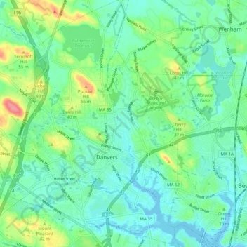
Nombre: Mapa topográfico Danvers, altitud, relieve.
Lugar: Danvers, Essex County, Massachusetts, United States (42.54016 -71.00281 42.61324 -70.90762)
Altitud media: 22 m
Altitud mínima: -2 m
Altitud máxima: 81 m
Otros mapas topográficos
Haga clic en un mapa para ver su topografía, su altitud y su relieve.
East Parish
United States > Massachusetts > Essex County > Boxford > Boxford > East Parish
Altitud media: 38 m
Mount Vernon Park
United States > Massachusetts > Essex County > Lawrence > Mount Vernon Park
Altitud media: 29 m
Amesbury
United States > Massachusetts > Essex County > Amesbury
Amesbury is located at 42°51′29″N 70°55′50″W / 42.85806°N 70.93056°W / 42.85806; -70.93056. According to the United States Census Bureau, the city has a total area of 13.7 square miles (35.5 km2), of which 12.3 square miles (31.8 km2) is land and 1.5 square miles (3.8 km2), or 10.65%, is…
Altitud media: 24 m