
Mapa topográfico Tabernash
Mapa interactivo
Haga clic en el mapa para ver la altitud.
Acerca de este mapa
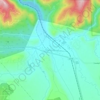
Nombre: Mapa topográfico Tabernash, altitud, relieve.
Lugar: Tabernash, Grand County, Colorado, 80478, United States (39.97360 -105.86307 40.01360 -105.82307)
Altitud media: 2.592 m
Altitud mínima: 2.519 m
Altitud máxima: 2.802 m
On August 10, 1984, a Cessna L-19 Bird Dog (registration N4584A), piloted by James Jeb Caddell, 36, crashed in a forest near Tabernash. The aircraft was en route from Granby to Jeffco Airport, Colorado. The wreckage was found by backpackers three years later on August 23, 1987. A 6½ minute video shot from a VHS camcorder mounted on the instrument panel was found at the site. The heavily damaged tape, some of it hanging from tree branches, was recovered and repaired by Colorado deputy sheriff Dale Wood. Subsequent analysis of the footage revealed that the pilot had not taken into account the density altitude conditions that existed on the day of the flight. The aircraft was unable to climb away from steadily rising terrain. In an attempt to return to the departure airfield, the pneumatic stall warning of the airplane sounded three times during a turn to the right. The pilot could be heard yelling, "Damn, hang on Ronnie!" to his one backseat passenger, Ronald Hugh Wilmond, 36, three seconds before impacting the terrain and trees.
Otros mapas topográficos
Haga clic en un mapa para ver su topografía, su altitud y su relieve.
Morse Mountain
United States > Colorado > Grand County
Morse Mountain, Grand County, Colorado, United States
Altitud media: 2.924 m
Grand Lake
United States > Colorado > Grand County
Grand Lake, Grand County, Colorado, United States
Altitud media: 2.630 m
Fraser
United States > Colorado > Grand County
Fraser, Grand County, Colorado, 80442, United States
Altitud media: 2.696 m
Winter Park
United States > Colorado > Grand County
Winter Park, Grand County, Colorado, United States
Altitud media: 3.068 m
Lake Granby
United States > Colorado > Grand County
Lake Granby, Grand County, Colorado, United States
Altitud media: 2.608 m
Granby
United States > Colorado > Grand County
Granby, Grand County, Colorado, United States
Altitud media: 2.555 m
Rabbit Ears Pass
United States > Colorado > Grand County
Rabbit Ears Pass, Grand County, Colorado, United States
Altitud media: 2.852 m
Bottle Peak
United States > Colorado > Grand County
Bottle Peak, Grand County, Colorado, United States
Altitud media: 3.283 m
Elk Mountain
United States > Colorado > Grand County
Elk Mountain, Grand County, Colorado, United States
Altitud media: 3.218 m
Kremmling
United States > Colorado > Grand County
Kremmling, Grand County, Colorado, 80459, United States
Altitud media: 2.251 m
Mount Flora
United States > Colorado > Grand County
Mount Flora, Grand County, Colorado, United States
Altitud media: 3.728 m
Indian Peaks Wilderness
United States > Colorado > Grand County
Indian Peaks Wilderness, Grand County, Colorado, United States
Altitud media: 3.080 m