
Mapa topográfico Luling
Mapa interactivo
Haga clic en el mapa para ver la altitud.
Acerca de este mapa
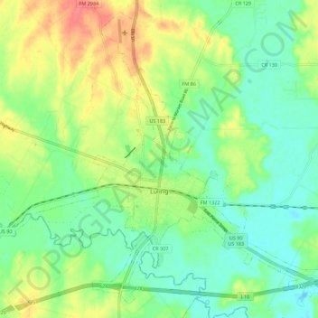
Nombre: Mapa topográfico Luling, altitud, relieve.
Lugar: Luling, Caldwell County, Texas, 78468, United States (29.64527 -97.70030 29.73462 -97.58941)
Altitud media: 121 m
Altitud mínima: 99 m
Altitud máxima: 156 m
Otros mapas topográficos
Haga clic en un mapa para ver su topografía, su altitud y su relieve.
Dale
United States > Texas > Caldwell County
Dale, Caldwell County, Texas, 78616, United States
Altitud media: 155 m
Uhland
United States > Texas > Caldwell County
Uhland, Caldwell County, Texas, United States
Altitud media: 180 m
Lockhart
United States > Texas > Caldwell County
Lockhart, Caldwell County, Texas, 78644, United States
Altitud media: 156 m
Fentress
United States > Texas > Caldwell County > Fentress
Fentress, Caldwell County, Texas, 78922, United States
Altitud media: 139 m
Lockhart
United States > Texas > Caldwell County > Lockhart > Lockhart
Lockhart, Caldwell County, Texas, 78644, United States
Altitud media: 157 m