
Mapa topográfico Eugene
Mapa interactivo
Haga clic en el mapa para ver la altitud.
Acerca de este mapa
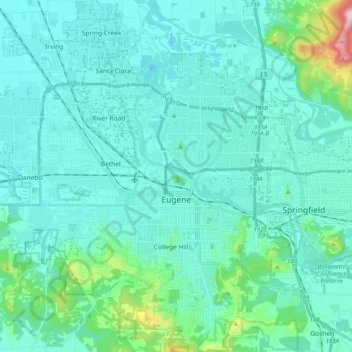
Nombre: Mapa topográfico Eugene, altitud, relieve.
Lugar: Eugene, Lane County, Oregon, United States (43.98753 -123.20876 44.13227 -123.03059)
Altitud media: 163 m
Altitud mínima: 88 m
Altitud máxima: 689 m
According to the United States Census Bureau, the city has a total area of 43.74 square miles (113.29 km2), of which 43.72 square miles (113.23 km2) is land and 0.02 square miles (0.05 km2) is water. Eugene is at an elevation of 426 feet (130 m).
Otros mapas topográficos
Haga clic en un mapa para ver su topografía, su altitud y su relieve.
Rainbow
United States > Oregon > Lane County > Rainbow
Rainbow, Lane County, Oregon, 97413, United States
Altitud media: 486 m
Fuji Mountain
United States > Oregon > Lane County
Fuji Mountain, Lane County, Oregon, United States
Altitud media: 1.885 m
Oakridge
United States > Oregon > Lane County
Oakridge, Lane County, Oregon, 97463, United States
Altitud media: 465 m
Springfield
United States > Oregon > Lane County > Springfield
Springfield, Lane County, Oregon, United States
Altitud media: 177 m
Florence
United States > Oregon > Lane County
Florence, Lane County, Oregon, United States
Altitud media: 22 m
Creswell
United States > Oregon > Lane County
Creswell, Lane County, Oregon, 97426, United States
Altitud media: 165 m