
Mapa topográfico Lake Secession
Mapa interactivo
Haga clic en el mapa para ver la altitud.
Acerca de este mapa
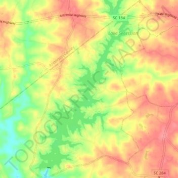
Nombre: Mapa topográfico Lake Secession, altitud, relieve.
Altitud media: 188 m
Altitud mínima: 144 m
Altitud máxima: 223 m
Secession Lake is a reservoir on the Rocky River, a tributary of the Savannah River. The spillway elevation is 548 feet (167 m) above sea level. The reservoir extends north into Anderson County, but the CDP consists only of residences built around the lake within Abbeville County. The Antreville CDP borders the Lake Secession CDP to the east.
Otros mapas topográficos
Haga clic en un mapa para ver su topografía, su altitud y su relieve.
Due West
United States > South Carolina > Abbeville County
Due West, Abbeville County, South Carolina, 29639, United States
Altitud media: 202 m
Keowee
United States > South Carolina > Abbeville County
Keowee, Abbeville County, South Carolina, 29656, United States
Altitud media: 214 m