
Mapa topográfico Cornish
Mapa interactivo
Haga clic en el mapa para ver la altitud.
Acerca de este mapa
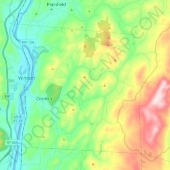
Nombre: Mapa topográfico Cornish, altitud, relieve.
Lugar: Cornish, Sullivan County, New Hampshire, United States (43.42379 -72.39912 43.52518 -72.22558)
Altitud media: 272 m
Altitud mínima: 83 m
Altitud máxima: 945 m
According to the United States Census Bureau, the town has a total area of 42.6 square miles (110.4 km2), of which 42.0 square miles (108.7 km2) are land and 0.66 square miles (1.7 km2) are water, comprising 1.54% of the town. The Connecticut River forms the western boundary of the town, which is also the New Hampshire–Vermont border. The town is drained by direct tributaries of the Connecticut: Blow-me-down Brook, Mill Brook, and Walker Brook; and by Redwater Brook, which flows south to the Sugar River in Claremont before that river joins the Connecticut. The long ridge of Croydon Mountain follows the eastern boundary of town; the highest point in town is a knob on Croydon Mountain which reaches an elevation of 2,323 ft (708 m) above sea level. The eastern part of the town is a portion of the approximately 25,000-acre (100 km2) Blue Mountain Forest Association private game preserve, also known locally as Corbin Park, named after its founder, Austin Corbin.
Otros mapas topográficos
Haga clic en un mapa para ver su topografía, su altitud y su relieve.
East Unity
United States > New Hampshire > Sullivan County > Unity
East Unity, Unity, Sullivan County, New Hampshire, United States
Altitud media: 399 m
Sunapee
United States > New Hampshire > Sullivan County
Sunapee, Sullivan County, New Hampshire, United States
Altitud media: 363 m
Croydon
United States > New Hampshire > Sullivan County
Croydon, Sullivan County, New Hampshire, United States
Altitud media: 372 m
Newport
United States > New Hampshire > Sullivan County
Newport, Sullivan County, New Hampshire, United States
Altitud media: 339 m
Ryder Corner
United States > New Hampshire > Sullivan County > Croydon
Ryder Corner, Croydon, Sullivan County, New Hampshire, 03754, United States
Altitud media: 352 m
Grantham
United States > New Hampshire > Sullivan County
Grantham, Sullivan County, New Hampshire, 03753, United States
Altitud media: 419 m
Unity
United States > New Hampshire > Sullivan County
Unity, Sullivan County, New Hampshire, United States
Altitud media: 369 m
Green Mountain
United States > New Hampshire > Sullivan County > Claremont
Green Mountain, Claremont, Sullivan County, New Hampshire, United States
Altitud media: 446 m
Goshen
United States > New Hampshire > Sullivan County > Goshen
Goshen, Sullivan County, New Hampshire, 03752, United States
Altitud media: 419 m
Eastman
United States > New Hampshire > Sullivan County > Grantham > Eastman
Eastman, Grantham, Sullivan County, New Hampshire, 03753, United States
Altitud media: 347 m
Acworth
United States > New Hampshire > Sullivan County
Acworth, Sullivan County, New Hampshire, 03601, United States
Altitud media: 380 m
Langdon
United States > New Hampshire > Sullivan County
Langdon, Sullivan County, New Hampshire, United States
Altitud media: 239 m
Mill Hollow
United States > New Hampshire > Sullivan County > Plainfield > Mill Hollow
Mill Hollow, Plainfield, Sullivan County, New Hampshire, 03770, United States
Altitud media: 313 m
Lempster
United States > New Hampshire > Sullivan County
Lempster, Sullivan County, New Hampshire, 03605, United States
Altitud media: 425 m
North Grantham
United States > New Hampshire > Sullivan County > Grantham > North Grantham
North Grantham, Grantham, Sullivan County, New Hampshire, 03753, United States
Altitud media: 386 m
Charlestown
United States > New Hampshire > Sullivan County
Charlestown, Sullivan County, New Hampshire, 03603, United States
Altitud media: 256 m
Claremont
United States > New Hampshire > Sullivan County
Claremont, Sullivan County, New Hampshire, United States
Altitud media: 236 m
Plainfield
United States > New Hampshire > Sullivan County > Plainfield
Plainfield, Sullivan County, New Hampshire, United States
Altitud media: 267 m