
Mapa topográfico Riggins
Mapa interactivo
Haga clic en el mapa para ver la altitud.
Acerca de este mapa
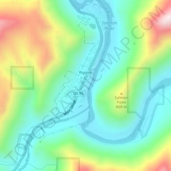
Nombre: Mapa topográfico Riggins, altitud, relieve.
Lugar: Riggins, Idaho County, Idaho, 83549, United States (45.40719 -116.33166 45.43308 -116.31000)
Altitud media: 706 m
Altitud mínima: 509 m
Altitud máxima: 1.144 m
Riggins is a city in the western United States in Idaho County, Idaho. Nestled deep in a canyon at the confluence of the Salmon and Little Salmon rivers in west central Idaho, it is approximately 150 highway miles (240 km) north of Boise, and 120 highway miles (190 km) south-southeast of Lewiston. The elevation is 1,821 feet (555 m) above sea level, and its population was 419 at the 2010 census.
Otros mapas topográficos
Haga clic en un mapa para ver su topografía, su altitud y su relieve.
Nugget Point
United States > Idaho > Idaho County
Nugget Point, Idaho County, Idaho, United States
Altitud media: 1.659 m
Grangeville
United States > Idaho > Idaho County
Grangeville, Idaho County, Idaho, United States
Altitud media: 1.037 m
The Maze
United States > Idaho > Idaho County
The Maze, Idaho County, Idaho, United States
Altitud media: 533 m
Dry Can Creek
United States > Idaho > Idaho County
Dry Can Creek, Idaho County, Idaho, United States
Altitud media: 1.163 m