
Mapa topográfico Pucklechurch
Mapa interactivo
Haga clic en el mapa para ver la altitud.
Acerca de este mapa
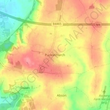
Nombre: Mapa topográfico Pucklechurch, altitud, relieve.
Altitud media: 96 m
Altitud mínima: 48 m
Altitud máxima: 131 m
The land of Pucklechurch is relatively prominent in elevation compared to surrounding areas and as such it was selected in the Bronze Age as the site of a tumulus (round barrow) at Shortwood Hill.