
Mapa topográfico Matlock
Mapa interactivo
Haga clic en el mapa para ver la altitud.
Acerca de este mapa
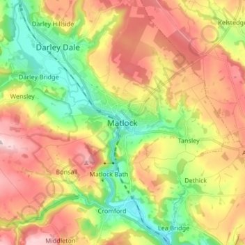
Nombre: Mapa topográfico Matlock, altitud, relieve.
Altitud media: 213 m
Altitud mínima: 76 m
Altitud máxima: 367 m
Otros mapas topográficos
Haga clic en un mapa para ver su topografía, su altitud y su relieve.
Tideswell CP
United Kingdom > England > Derbyshire > Derbyshire Dales
Tideswell is a village, civil parish, and ward in the Peak District of Derbyshire, England. It lies 6 miles (9.7 km) east of Buxton on the B6049, in a wide valley on a limestone plateau, at an altitude of 1,000 feet (300 m) above sea level, and is within the District of Derbyshire Dales. The population…
Altitud media: 321 m
Blackwell in the Peak CP
United Kingdom > England > Derbyshire > Derbyshire Dales
Altitud media: 331 m
Nether Haddon CP
United Kingdom > England > Derbyshire > Derbyshire Dales
The name "Haddon" means "Heath Hill", the "Nether" referring to being below "Over Haddon". Elevations reach 211 m above Ordnance Datum, just above headsprings in the north. In the east, before flowing into Rowsley, the Wye is at 106 m, which is similar to the Hall at the centre of the civil parish. To the…
Altitud media: 170 m
Taddington Dale
United Kingdom > England > Derbyshire > Derbyshire Dales > Brushfield CP
Altitud media: 281 m
Catcliff Wood
United Kingdom > England > Derbyshire > Derbyshire Dales > Bakewell CP
Altitud media: 173 m
Ashbourne CP
United Kingdom > England > Derbyshire > Derbyshire Dales
Ashbourne lies at 53°01′N 01°44′W / 53.017°N 1.733°W / 53.017; -1.733. Ashbourne Green and Sturston are hamlets close by. Henmore Brook, a tributary of the River Dove, flows through the middle of the town. It has an elevation of 400 feet (122 m).
Altitud media: 147 m
Darley Dale
United Kingdom > England > Derbyshire > Derbyshire Dales > Darley Hillside
Altitud media: 206 m
Magpie Mine
United Kingdom > England > Derbyshire > Derbyshire Dales > Ashford in the Water CP
Altitud media: 303 m
Tideswell CP
United Kingdom > England > Derbyshire > Derbyshire Dales
Tideswell is a village and civil parish in the Peak District of Derbyshire, England. It lies 6 miles (9.7 km) east of Buxton on the B6049, in a wide valley on a limestone plateau, at an altitude of 1,000 feet (300 m) above sea level, and is within the District of Derbyshire Dales. The population (including…
Altitud media: 321 m
Winster CP
United Kingdom > England > Derbyshire > Derbyshire Dales
Winster is a village in the English Derbyshire Dales about 5 miles (8 km) from Matlock and 6 miles (10 km) from Bakewell at an altitude of approximately 820 feet (250 m). It was formerly a centre for the lead mining industry. The village lies within the Peak District National Park and The Peak District…
Altitud media: 274 m
Hathersage
United Kingdom > England > Derbyshire > Derbyshire Dales
The Fat Boys Stanage Struggle is a popular local fell race that starts in Hathersage—altitude 91 metres (299 ft)—and routes up to and along Stanage Edge to High Neb—458 metres (1,503 ft)—before returning to the village 367 metres (1,204 ft) below.
Altitud media: 311 m
Bakewell CP
United Kingdom > England > Derbyshire > Derbyshire Dales
The Manchester, Buxton, Matlock and Midlands Junction Railway opened Bakewell railway station in 1862, then became part of the Midland Railway and later of the LMS main line from London to Manchester. John Ruskin objected to what he saw as desecration of the Derbyshire countryside and to the fact that "a…
Altitud media: 194 m
Elton CP
United Kingdom > England > Derbyshire > Derbyshire Dales
At 271 metres (889 ft) above sea level, Elton is less sheltered from the wind than settlements at lower elevation, and it therefore has a reputation for being cold. The highest point on Elton Moor, known as Blake Low, is 330 metres (1,080 ft) above sea level; at this location is Elton Common trig point…
Altitud media: 268 m
Stoke Brook
United Kingdom > England > Derbyshire > Derbyshire Dales > Calver Sough
Altitud media: 197 m
Yarncliff Wood
United Kingdom > England > Derbyshire > Derbyshire Dales > Grindleford
Altitud media: 260 m
Biggin Dale NNR
United Kingdom > England > Derbyshire > Derbyshire Dales > Biggin
Altitud media: 298 m
Froggatt Edge
United Kingdom > England > Derbyshire > Derbyshire Dales > Froggatt
Froggatt Edge is considered the second most popular between the Eastern Edges. Due to its position the edge avoids the worst of the weather. Froggatt is famous for its slabs, but it also has a good amount of climbs including cracks.There are two usual approaches for climbing: the first one is from the parking…
Altitud media: 229 m
Riber Castle
United Kingdom > England > Derbyshire > Derbyshire Dales > Matlock > Starkholmes
Altitud media: 169 m
Birchover CP
United Kingdom > England > Derbyshire > Derbyshire Dales > Birchover CP
Altitud media: 231 m
Curbar Edge
United Kingdom > England > Derbyshire > Derbyshire Dales > Calver Sough
Altitud media: 251 m