
Mapa topográfico Billings
Mapa interactivo
Haga clic en el mapa para ver la altitud.
Acerca de este mapa
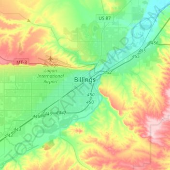
Nombre: Mapa topográfico Billings, altitud, relieve.
Lugar: Billings, Yellowstone County, Montana, United States (45.71067 -108.69152 45.85265 -108.43592)
Altitud media: 1.023 m
Altitud mínima: 923 m
Altitud máxima: 1.219 m
Two-thirds of the city is in the Yellowstone Valley and the South Hills area and one-third in the Heights-Lockwood area. The city is divided by the Rims, long cliffs, also called the Rimrocks. The Rims run to the north and east of the downtown core, separating it from the Heights to the north and Lockwood to the east, with the cliffs to the north being 500 feet (150 m) tall and to the east of downtown, the face rises 800 feet (240 m). The elevation of Billings is 3,126 feet (953 m) above sea level. The Yellowstone River runs through the southeast portion of the city. According to the United States Census Bureau, the city has an area of 43.52 square miles (112.72 km2), of which 43.41 square miles (112.43 km2) is land and 0.11 square miles (0.28 km2) is water.
Otros mapas topográficos
Haga clic en un mapa para ver su topografía, su altitud y su relieve.
Huntley
United States > Montana > Yellowstone County
Huntley, Yellowstone County, Montana, United States
Altitud media: 924 m
Laurel
United States > Montana > Yellowstone County
Laurel, Yellowstone County, Montana, United States
Altitud media: 1.019 m
Yegen
United States > Montana > Yellowstone County
Yegen, Yellowstone County, Montana, United States
Altitud media: 981 m