
Mapa topográfico Olango Island
Mapa interactivo
Haga clic en el mapa para ver la altitud.
Acerca de este mapa
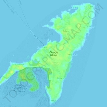
Nombre: Mapa topográfico Olango Island, altitud, relieve.
Lugar: Olango Island, Lapu-Lapu, Cebu, Central Visayas, Philippines (10.23741 124.01964 10.28879 124.07437)
Altitud media: 2 m
Altitud mínima: -3 m
Altitud máxima: 13 m
Otros mapas topográficos
Haga clic en un mapa para ver su topografía, su altitud y su relieve.
Mactan
Philippines > Cebu > Lapu-Lapu
Mactan, Lapu-Lapu, Cebu, Central Visayas, Philippines
Altitud media: 3 m
Gilutongan Island
Philippines > Cebu > Lapu-Lapu
Gilutongan Island, Lapu-Lapu, Cebu, Central Visayas, Philippines
Altitud media: 0 m
Sulpa Islet
Philippines > Cebu > Lapu-Lapu
Sulpa Islet, Lapu-Lapu, Cebu, Central Visayas, Philippines
Altitud media: 0 m
Hilutungan Sanctuary
Philippines > Cebu > Lapu-Lapu
Hilutungan Sanctuary, Simean Amodia, Pacific Grand Villas, Lapu-Lapu, Cebu, Central Visayas, 6017, Philippines
Altitud media: 0 m