
Mapa topográfico Catanzaro
Mapa interactivo
Haga clic en el mapa para ver la altitud.
Acerca de este mapa
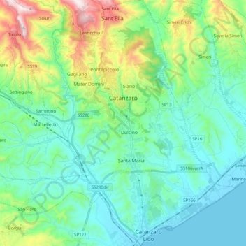
Nombre: Mapa topográfico Catanzaro, altitud, relieve.
Lugar: Catanzaro, Calabria, Italy (38.81484 16.53903 38.96858 16.68686)
Altitud media: 195 m
Altitud mínima: 0 m
Altitud máxima: 847 m
Catanzaro overlooks the Gulf of Squillace, in the Ionian Sea. The district of Catanzaro stretches from the sea to an elevation of 600 metres (2,000 ft). The historic center is approximately 300 metres (980 ft) above sea level. The town dates back to the valley of Fiumarella (formerly known as River Zaro). The Bishopric, St. Tryphon (or San Rocco) and St. John (or castle) marks the city's historical center and is connected to the North Sila. Due to its particular geography, the municipality gets wet from the sea, and is still subjected to a snowy winter. Catanzaro's rivers include the main stream of the Fiumarella (in local dialect Hjiumareddha), which joins with the river Musofalo, and the torrent Corach (formerly called Crotalo).