
Mapa topográfico Duncan
Mapa interactivo
Haga clic en el mapa para ver la altitud.
Acerca de este mapa
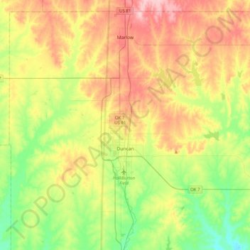
Nombre: Mapa topográfico Duncan, altitud, relieve.
Lugar: Duncan, Stephens County, Oklahoma, 73533, United States (34.42751 -98.05468 34.63795 -97.65801)
Altitud media: 350 m
Altitud mínima: 280 m
Altitud máxima: 442 m
Otros mapas topográficos
Haga clic en un mapa para ver su topografía, su altitud y su relieve.
Bray
United States > Oklahoma > Stephens County
Bray, Stephens County, Oklahoma, United States
Altitud media: 368 m
Velma
United States > Oklahoma > Stephens County
Velma, Stephens County, Oklahoma, 73491, United States
Altitud media: 320 m
Comanche
United States > Oklahoma > Stephens County
Comanche, Stephens County, Oklahoma, 73529, United States
Altitud media: 315 m
Loco
United States > Oklahoma > Stephens County
Loco, Stephens County, Oklahoma, United States
Altitud media: 288 m
Countyline
United States > Oklahoma > Stephens County
Countyline, Stephens County, Oklahoma, 73425, United States
Altitud media: 310 m
Marlow
United States > Oklahoma > Stephens County
Marlow, Stephens County, Oklahoma, 73055, United States
Altitud media: 385 m