
Mapa topográfico Bartlesville
Mapa interactivo
Haga clic en el mapa para ver la altitud.
Acerca de este mapa
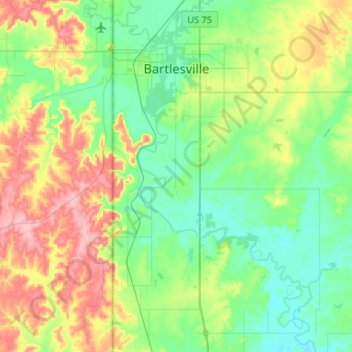
Nombre: Mapa topográfico Bartlesville, altitud, relieve.
Lugar: Bartlesville, Washington County, Oklahoma, United States (36.57206 -96.01276 36.78339 -95.88979)
Altitud media: 231 m
Altitud mínima: 189 m
Altitud máxima: 317 m
Otros mapas topográficos
Haga clic en un mapa para ver su topografía, su altitud y su relieve.
Dewey
United States > Oklahoma > Washington County
Dewey, Washington County, Oklahoma, 74029, United States
Altitud media: 211 m
Bartlesville
United States > Oklahoma > Washington County > Bartlesville
Bartlesville, Washington County, Oklahoma, 74003-4330, United States
Altitud media: 241 m