
Mapa topográfico Minot
Mapa interactivo
Haga clic en el mapa para ver la altitud.
Acerca de este mapa
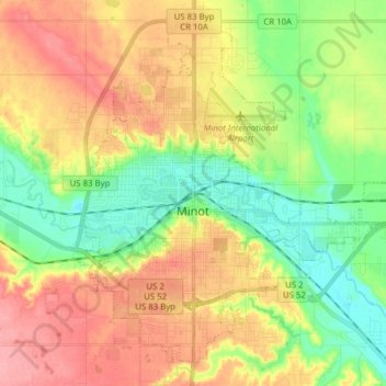
Nombre: Mapa topográfico Minot, altitud, relieve.
Lugar: Minot, Ward County, North Dakota, United States (48.19164 -101.34295 48.28304 -101.18767)
Altitud media: 510 m
Altitud mínima: 467 m
Altitud máxima: 558 m
The elevation of the river at the city center is 1,540 feet (470 m) above sea level. The valley sits 160 feet (49 m) below the surrounding plains; the elevation at the Minot International Airport on North Hill is 1,716 feet (523 m). The city has several small horseshoe-shaped oxbow lakes within its limits near the river, created by the Mouse's meandering course.
Otros mapas topográficos
Haga clic en un mapa para ver su topografía, su altitud y su relieve.
Kenmare
United States > North Dakota > Ward County
Kenmare, Ward County, North Dakota, United States
Altitud media: 577 m
Burlington
United States > North Dakota > Ward County
Burlington, Ward County, North Dakota, United States
Altitud media: 500 m
Sawyer
United States > North Dakota > Ward County
Sawyer, Ward County, North Dakota, United States
Altitud media: 488 m
Berthold
United States > North Dakota > Ward County > Berthold
Berthold, Ward County, North Dakota, United States
Altitud media: 634 m