
Mapa topográfico Brooke County
Mapa interactivo
Haga clic en el mapa para ver la altitud.
Brooke County
According to the United States Census Bureau, the county has a total area of 93 square miles (240 km2), of which 89 square miles (230 km2) is land and 3.4 square miles (8.8 km2) (3.6%) is water. It is the second-smallest county in West Virginia by area. The highest point of elevation in Brooke County is approximately 1372 ft. and located about 1.5 miles south of Franklin.[1]
Acerca de este mapa
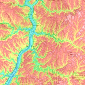
Nombre: Mapa topográfico Brooke County, altitud, relieve.
Lugar: Brooke County, West Virginia, United States (40.15973 -80.68025 40.39976 -80.51886)
Altitud media: 320 m
Altitud mínima: 194 m
Altitud máxima: 424 m
Otros mapas topográficos
Haga clic en un mapa para ver su topografía, su altitud y su relieve.
White Top
United States > West Virginia > Randolph County
White Top is a knob and spur of Cheat Mountain in southeastern Randolph County, West Virginia, USA. Sitting at an elevation of 4,085 feet (1,245 m), it is located just west of the Shavers Fork of Cheat River and Cheat Bridge. While White Top was originally crossed by the Staunton–Parkersburg Turnpike,…
Altitud media: 1.159 m
Spruce Knob
United States > West Virginia > Pendleton County
Spruce Mountain, located in eastern West Virginia, is the highest ridge of the Allegheny Mountains. The whale-backed ridge extends for only 16 miles (26 km) from northeast to southwest, but several of its peaks exceed 4,500 feet (1,400 m) in elevation. The summit, Spruce Knob (4,863 ft; 1,482 m), is the…
Altitud media: 1.274 m
Alderson Recreation Area
United States > West Virginia > Greenbrier County > Alderson
Altitud media: 501 m
Spruce Knob Lake
United States > West Virginia > Randolph County
Spruce Knob Lake is a 23-acre (0.093 km2) reservoir located within the Monongahela National Forest in Randolph County, West Virginia, USA. The recreation area surrounding Spruce Knob Lake contains camping and picnicking facilities as well as a boating site. At an elevation of 3,840 feet, it is the highest lake…
Altitud media: 1.204 m