
Mapa topográfico Hull
Mapa interactivo
Haga clic en el mapa para ver la altitud.
Acerca de este mapa
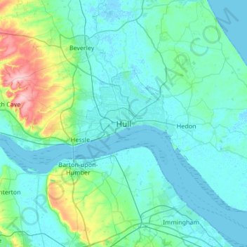
Nombre: Mapa topográfico Hull, altitud, relieve.
Lugar: Hull, Kingston upon Hull, England, HU1 3RA, United Kingdom (53.58357 -0.49948 53.90357 -0.17948)
Altitud media: 21 m
Altitud mínima: -4 m
Altitud máxima: 168 m
Kingston upon Hull is on the northern bank of the Humber Estuary. The city centre is west of the River Hull and close to the Humber. The city is built upon alluvial and glacial deposits which overlie chalk rocks but the underlying chalk has no influence on the topography. The land within the city is generally very flat and is only 2 to 4 metres (6.5 to 13 ft) above sea level. Because of the relative flatness of the site there are few physical constraints upon building and many open areas are the subject of pressures to build.
Otros mapas topográficos
Haga clic en un mapa para ver su topografía, su altitud y su relieve.
Sutton
United Kingdom > England > Kingston upon Hull > Sutton
Sutton, Kingston upon Hull, Yorkshire and the Humber, England, HU7 4UF, United Kingdom
Altitud media: 3 m