
Mapa topográfico Cannon Beach
Mapa interactivo
Haga clic en el mapa para ver la altitud.
Acerca de este mapa
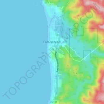
Nombre: Mapa topográfico Cannon Beach, altitud, relieve.
Lugar: Cannon Beach, Clatsop County, Oregon, United States (45.85893 -123.97004 45.91103 -123.94945)
Altitud media: 42 m
Altitud mínima: -3 m
Altitud máxima: 250 m
Cannon Beach is recognized by the well-known landmark Haystack Rock, located southwest of downtown Cannon Beach. This sea stack has an elevation of 235 feet (72 m) and is often accessible at low tide, especially in the summertime. There is a small cave system that penetrates its igneous rock that can be seen from the coastline. The rock is also protected as part of Oregon Islands National Wildlife Refuge and events are not allowed within 100 feet (30 m) of either side of the rock. Near Haystack Rock are the Needles, two tall rocks rising straight out of the water.
Otros mapas topográficos
Haga clic en un mapa para ver su topografía, su altitud y su relieve.
Astoria
United States > Oregon > Clatsop County
Astoria, Clatsop County, Oregon, 97103, United States
Altitud media: 16 m
Warrenton
United States > Oregon > Clatsop County
Warrenton, Clatsop County, Oregon, United States
Altitud media: 4 m
Astoria
United States > Oregon > Clatsop County > Astoria
Astoria, Clatsop County, Oregon, 97103, United States
Altitud media: 17 m
Westport
United States > Oregon > Clatsop County > Westport
Westport, Clatsop County, Oregon, United States
Altitud media: 61 m