
Mapa topográfico Apple Valley
Mapa interactivo
Haga clic en el mapa para ver la altitud.
Acerca de este mapa
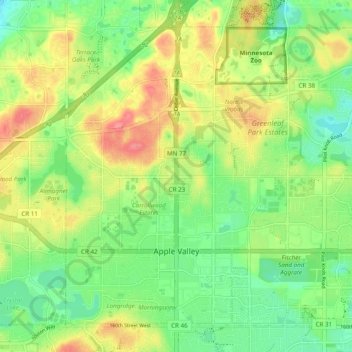
Nombre: Mapa topográfico Apple Valley, altitud, relieve.
Lugar: Apple Valley, Dakota County, Minnesota, 55124, United States (44.71734 -93.24835 44.77589 -93.15134)
Altitud media: 301 m
Altitud mínima: 270 m
Altitud máxima: 343 m
According to the United States Census Bureau, the city has a total area of 17.57 square miles (45.51 km2), of which 16.86 square miles (43.67 km2) is land and 0.71 square miles (1.84 km2) is water. The city's geography is rolling, with elevation from the lowest to the highest points in the city varying by one hundred feet (thirty metres) or more. The downtown area and its adjacent residential district (which formed the original core of the city when it was incorporated) are in a shallow valley.
Otros mapas topográficos
Haga clic en un mapa para ver su topografía, su altitud y su relieve.
Hampton
United States > Minnesota > Dakota County
Hampton, Dakota County, Minnesota, 55031, United States
Altitud media: 297 m
Inver Grove Heights
United States > Minnesota > Dakota County
Inver Grove Heights, Dakota County, Minnesota, United States
Altitud media: 260 m
Randolph
United States > Minnesota > Dakota County
Randolph, Dakota County, Minnesota, United States
Altitud media: 270 m
Burnsville
United States > Minnesota > Dakota County
Burnsville, Dakota County, Minnesota, United States
Altitud media: 271 m
South St. Paul
United States > Minnesota > Dakota County
South St. Paul, Dakota County, Minnesota, 55075, United States
Altitud media: 257 m
Eagan
United States > Minnesota > Dakota County > Eagan
Eagan, Dakota County, Minnesota, United States
Altitud media: 267 m
Empire Lake
United States > Minnesota > Dakota County
Empire Lake, Dakota County, Minnesota, United States
Altitud media: 277 m
Coates
United States > Minnesota > Dakota County > Coates > Coates
Coates, Dakota County, Minnesota, United States
Altitud media: 280 m
Mendota
United States > Minnesota > Dakota County
Mendota, Dakota County, Minnesota, 55150, United States
Altitud media: 242 m
Farmington
United States > Minnesota > Dakota County > Farmington > Farmington
Farmington, Dakota County, Minnesota, 55024, United States
Altitud media: 280 m
Rosemount
United States > Minnesota > Dakota County
Rosemount, Dakota County, Minnesota, 55068, United States
Altitud media: 287 m
Lilydale
United States > Minnesota > Dakota County
Lilydale, Dakota County, Minnesota, United States
Altitud media: 257 m
Burnsville
United States > Minnesota > Dakota County > Burnsville > Burnsville
Burnsville, Dakota County, Minnesota, 55337, United States
Altitud media: 275 m
Lakeville
United States > Minnesota > Dakota County
Lakeville, Dakota County, Minnesota, 55044, United States
Altitud media: 305 m
Farmington
United States > Minnesota > Dakota County
Farmington, Dakota County, Minnesota, 55024, United States
Altitud media: 280 m
Coates
United States > Minnesota > Dakota County
Coates, Dakota County, Minnesota, United States
Altitud media: 280 m