
Mapa topográfico Barrington
Mapa interactivo
Haga clic en el mapa para ver la altitud.
Barrington
Barrington lies on a low, mostly flat plain bordering the sea. This plain, composed mostly of layers of clay, gravel, sand, and silt soils, was formed by a melting glacier towards the end of the last ice age. Bedrock underlying the soil is largely composed of shales, sandstone, and conglomerate rock, with some outcrops of quartz. A few extremes in elevation, such as Nayatt Point, Primrose and Prince's Hill, rise to heights of fifty feet.
Acerca de este mapa
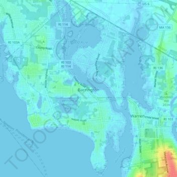
Nombre: Mapa topográfico Barrington, altitud, relieve.
Altitud media: 4 m
Altitud mínima: -7 m
Altitud máxima: 47 m