
Mapa topográfico Sayre
Mapa interactivo
Haga clic en el mapa para ver la altitud.
Acerca de este mapa
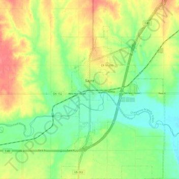
Nombre: Mapa topográfico Sayre, altitud, relieve.
Lugar: Sayre, Beckham County, Oklahoma, 73662, United States (35.24766 -99.65779 35.33907 -99.59298)
Altitud media: 567 m
Altitud mínima: 537 m
Altitud máxima: 607 m
Sayre is located on the North Fork of the Red River, at an elevation of 1,800 feet (550 m) and 128 miles (206 km) west of Oklahoma City. The area is dominated by low rolling red clay hills.
Otros mapas topográficos
Haga clic en un mapa para ver su topografía, su altitud y su relieve.
Texola
United States > Oklahoma > Beckham County
Texola, Beckham County, Oklahoma, 73668, United States
Altitud media: 654 m
Sweetwater
United States > Oklahoma > Beckham County
Sweetwater, Beckham County, Oklahoma, 73666, United States
Altitud media: 663 m
Erick
United States > Oklahoma > Beckham County
Erick, Beckham County, Oklahoma, 73645, United States
Altitud media: 631 m
Sayre
United States > Oklahoma > Beckham County
Sayre, Beckham County, Oklahoma, 73662, United States
Altitud media: 567 m
Sayre
United States > Oklahoma > Beckham County > Sayre > Sayre
Sayre, Beckham County, Oklahoma, 73662, United States
Altitud media: 560 m
Elk City
United States > Oklahoma > Beckham County
Elk City, Beckham County, Oklahoma, United States
Altitud media: 588 m