
Mapa topográfico Geldern
Mapa interactivo
Haga clic en el mapa para ver la altitud.
Acerca de este mapa
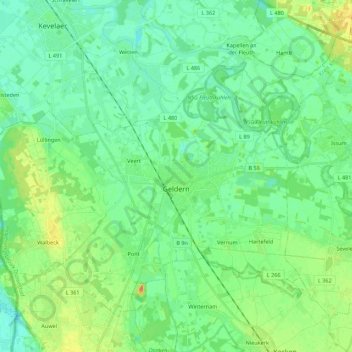
Nombre: Mapa topográfico Geldern, altitud, relieve.
Lugar: Geldern, Kreis Kleve, North Rhine-Westphalia, 47608, Germany (51.46713 6.20062 51.57657 6.42059)
Altitud media: 28 m
Altitud mínima: 16 m
Altitud máxima: 54 m
Geldern lies in the plains of the lower, northern Rhineland, west of the Rhine. Its average elevation is 27 m AMSL. The river Niers, a tributary of the Meuse (Maas), flows through Geldern. The stream Gelderner Fleuth flows into the Niers in Geldern.
Otros mapas topográficos
Haga clic en un mapa para ver su topografía, su altitud y su relieve.
In der Lecht
Germany > North Rhine-Westphalia > Kreis Kleve > Kalkar
In der Lecht, Kalkar, Bedburg-Hau, Kreis Kleve, North Rhine-Westphalia, 47546, Germany
Altitud media: 34 m
Bennenbroek
Germany > North Rhine-Westphalia > Kreis Kleve > Straelen
Bennenbroek, Straelen, Kreis Kleve, North Rhine-Westphalia, 47638, Germany
Altitud media: 24 m
Goch
Germany > North Rhine-Westphalia > Kreis Kleve
Goch, Kreis Kleve, North Rhine-Westphalia, 47574, Germany
Altitud media: 24 m
Uedem
Germany > North Rhine-Westphalia > Kreis Kleve > Uedem
Uedem, Kreis Kleve, North Rhine-Westphalia, 47589, Germany
Altitud media: 31 m
Kalkar
Germany > North Rhine-Westphalia > Kreis Kleve > Kalkar
Kalkar, Kreis Kleve, North Rhine-Westphalia, 47546, Germany
Altitud media: 22 m
Wachtendonk
Germany > North Rhine-Westphalia > Kreis Kleve > Wachtendonk
Wachtendonk, Kreis Kleve, North Rhine-Westphalia, 47669, Germany
Altitud media: 35 m
Jan
Germany > North Rhine-Westphalia > Kreis Kleve > Kranenburg
Jan, Kranenburg, Kreis Kleve, North Rhine-Westphalia, Germany
Altitud media: 27 m
Emmerich on the Rhine
Germany > North Rhine-Westphalia > Kreis Kleve
Emmerich on the Rhine, Kreis Kleve, North Rhine-Westphalia, 46446, Germany
Altitud media: 18 m
Issum
Germany > North Rhine-Westphalia > Kreis Kleve
Issum, Kreis Kleve, North Rhine-Westphalia, 47661, Germany
Altitud media: 31 m