
Mapa topográfico Gaspereau Mountain
Mapa interactivo
Haga clic en el mapa para ver la altitud.
Acerca de este mapa
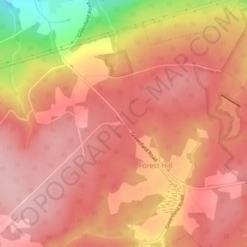
Nombre: Mapa topográfico Gaspereau Mountain, altitud, relieve.
Altitud media: 185 m
Altitud mínima: 45 m
Altitud máxima: 237 m
Otros mapas topográficos
Haga clic en un mapa para ver su topografía, su altitud y su relieve.
Davison Street
Canada > Nova Scotia > Municipality of the County of Kings > Forest Hill
Davison Street, Forest Hill, Municipality of the County of Kings, Kings County, Nova Scotia, B4P 2R1, Canada
Altitud media: 195 m