
Mapa topográfico Bradford
Mapa interactivo
Haga clic en el mapa para ver la altitud.
Acerca de este mapa
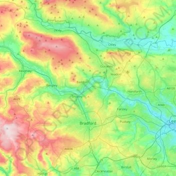
Nombre: Mapa topográfico Bradford, altitud, relieve.
Altitud media: 175 m
Altitud mínima: 28 m
Altitud máxima: 450 m
Bradford is located at 53°45′00″N 01°50′00″W / 53.75000°N 1.83333°W / 53.75000; -1.83333 (53.7500, -1.8333)1. Topographically, it is located in the eastern moorland region of the South Pennines.
Otros mapas topográficos
Haga clic en un mapa para ver su topografía, su altitud y su relieve.
Keighley
United Kingdom > England > Bradford > Long Lee
Keighley, Long Lee, Bradford, West Yorkshire, England, United Kingdom
Altitud media: 223 m
Queensbury
United Kingdom > England > Bradford
Queensbury, Bradford, West Yorkshire, England, BD13 2FR, United Kingdom
Altitud media: 284 m
Ilkley
United Kingdom > England > Bradford
Ilkley, Bradford, West Yorkshire, Yorkshire and the Humber, England, United Kingdom
Altitud media: 221 m