
Mapa topográfico Stavelot
Mapa interactivo
Haga clic en el mapa para ver la altitud.
Acerca de este mapa
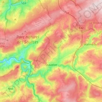
Nombre: Mapa topográfico Stavelot, altitud, relieve.
Lugar: Stavelot, Verviers, Liège, Wallonia, 4970, Belgium (50.33550 5.85104 50.49632 6.03048)
Altitud media: 431 m
Altitud mínima: 198 m
Altitud máxima: 639 m
Stavelot has an oceanic climate influenced by its high elevation and inland position towards a more continental type by Belgian standards. Being located at a lower elevation than neighbouring village Malmedy at the other end of the original layout of the Spa-Francorchamps race track, Stavelot is slightly milder, drier and sunnier than Malmedy year round.
Otros mapas topográficos
Haga clic en un mapa para ver su topografía, su altitud y su relieve.
Robertville
Robertville, Waimes, Verviers, Liège, Wallonia, Belgium
Altitud media: 570 m
Baraque Michel
Belgium > Liège > Verviers > Jalhay
Baraque Michel, Jalhay, Verviers, Liège, Wallonia, 4845, Belgium
Altitud media: 652 m
Arbrefontaine
Belgium > Liège > Verviers > Arbrefontaine
Arbrefontaine, Lierneux, Verviers, Liège, Wallonia, 4990, Belgium
Altitud media: 448 m
Francorchamps
Belgium > Liège > Verviers > Stavelot
Francorchamps, Stavelot, Verviers, Liège, Wallonia, 4970, Belgium
Altitud media: 482 m
Signal de Botrange
Belgium > Liège > Verviers > Robertville
Signal de Botrange, Robertville, Waimes, Verviers, Liège, Wallonia, Belgium
Altitud media: 658 m
Thimister-Clermont
Thimister-Clermont, Verviers, Liège, Wallonia, 4890, Belgium
Altitud media: 261 m
Saint Vith
Saint Vith, Verviers, Liège, Wallonia, 4780, Belgium
Altitud media: 492 m