
Haz una donación
Equípate para tu próxima aventura:
Como asociado de Amazon, este sitio gana comisiones por las compras que califican, sin ningún costo adicional para usted.
Mapa topográfico Arzai
Haga clic en el mapa para ver la altitud.
Haz una donación
Equípate para tu próxima aventura:
Como asociado de Amazon, este sitio gana comisiones por las compras que califican, sin ningún costo adicional para usted.
Acerca de este mapa
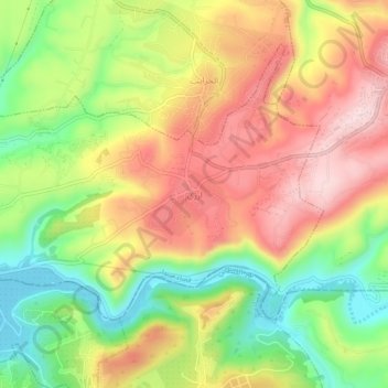
Nombre: Mapa topográfico Arzai, altitud, relieve.
Lugar: Arzai, Sidon District, South Governorate, Lebanon (33.31323 35.27863 33.35323 35.31863)
Altitud media: 158 m
Altitud mínima: 8 m
Altitud máxima: 302 m
Haz una donación
Equípate para tu próxima aventura:
Como asociado de Amazon, este sitio gana comisiones por las compras que califican, sin ningún costo adicional para usted.
Otros mapas topográficos
Haga clic en un mapa para ver su topografía, su altitud y su relieve.
Sidon
The city of Sidon is administered by the Municipality of Sidon. The municipality is constituted of a council of 21 members including the City Mayor and his Deputy. It has administrative and financial independence but remains under the control and supervision of the central government, specifically the Ministry…
Altitud media: 38 m
Haz una donación
Equípate para tu próxima aventura:
Como asociado de Amazon, este sitio gana comisiones por las compras que califican, sin ningún costo adicional para usted.
Sidon
The city of Sidon is administered by the Municipality of Sidon. The municipality is constituted of a council of 21 members including the City Mayor and his Deputy. It has administrative and financial independence but remains under the control and supervision of the central government, specifically the Ministry…
Altitud media: 38 m
Sidon
The city of Sidon is administered by the Municipality of Sidon. The municipality is constituted of a council of 21 members including the City Mayor and his Deputy. It has administrative and financial independence but remains under the control and supervision of the central government, specifically the Ministry…
Altitud media: 44 m
Haz una donación
Equípate para tu próxima aventura:
Como asociado de Amazon, este sitio gana comisiones por las compras que califican, sin ningún costo adicional para usted.
Haz una donación
Equípate para tu próxima aventura:
Como asociado de Amazon, este sitio gana comisiones por las compras que califican, sin ningún costo adicional para usted.
Tyre
Since 2008, a Lebanese-French team under the direction by Pierre-Louis Gatier of the University of Lyon has been conducting archaeological and topographical work. When international archeological missions in Syria came to a halt after 2012 due to the war there, some of them instead started excavations in Tyre,…
Altitud media: 5 m
Haz una donación
Equípate para tu próxima aventura:
Como asociado de Amazon, este sitio gana comisiones por las compras que califican, sin ningún costo adicional para usted.
Tyre
Since 2008, a Lebanese French team under the direction by Pierre-Louis Gatier of the University of Lyon has been conducting archaeological and topographical work. When international archeological missions in Syria came to a halt after 2012 due to the war there, some of them instead started excavations in Tyre,…
Altitud media: 5 m