
Haz una donación
Equípate para tu próxima aventura:
Como asociado de Amazon, este sitio gana comisiones por las compras que califican, sin ningún costo adicional para usted.
Mapa topográfico Yorkwood
Haga clic en el mapa para ver la altitud.
Haz una donación
Equípate para tu próxima aventura:
Como asociado de Amazon, este sitio gana comisiones por las compras que califican, sin ningún costo adicional para usted.
Acerca de este mapa
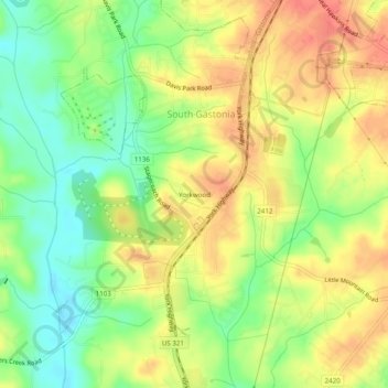
Nombre: Mapa topográfico Yorkwood, altitud, relieve.
Altitud media: 225 m
Altitud mínima: 195 m
Altitud máxima: 251 m
Haz una donación
Equípate para tu próxima aventura:
Como asociado de Amazon, este sitio gana comisiones por las compras que califican, sin ningún costo adicional para usted.
Otros mapas topográficos
Haga clic en un mapa para ver su topografía, su altitud y su relieve.
Spencer Mountain
United States > North Carolina > Gaston County
The town is located at the base of Spencer Mountain, a 1,250-foot (380 m) summit to the south. The town is sited along the South Fork Catawba River at an elevation of 679 feet (207 m).
Altitud media: 223 m
Cherryville
United States > North Carolina > Gaston County
Cherryville is located in Cherryville Township at an elevation of 1,007 feet (307 m). According to the United States Census Bureau, the city covers a total area of 5.50 square miles (14.25 km2), of which 5.49 square miles (14.22 km2) is land and 0.012 square miles (0.03 km2), or 0.21%, is water. The small…
Altitud media: 277 m
Haz una donación
Equípate para tu próxima aventura:
Como asociado de Amazon, este sitio gana comisiones por las compras que califican, sin ningún costo adicional para usted.
Mountain Island Lake
United States > North Carolina > Gaston County > Mount Holly
Mountain Island Lake is a lake northwest of Charlotte, North Carolina created in 1924 to coincide with the building of Mountain Island Hydroelectric Station. It is named after the mountain which appears as an island in the lake, and the surrounding area is identified by the lake's name. The shape of the lake…
Altitud media: 216 m
Bessemer City
United States > North Carolina > Gaston County
According to the United States Census Bureau, the city has a total area of 4.8 square miles (12.5 km2), of which 4.8 square miles (12.4 km2) is land and 0.039 square miles (0.1 km2), or 0.78%, is water. The elevation at city hall is 904 feet (276 m) above sea level.
Altitud media: 258 m
Haz una donación
Equípate para tu próxima aventura:
Como asociado de Amazon, este sitio gana comisiones por las compras que califican, sin ningún costo adicional para usted.
Cherryville
United States > North Carolina > Gaston County
Cherryville is located in Cherryville Township at 35°22′52″N 81°22′45″W / 35.38111°N 81.37917°W / 35.38111; -81.37917 (35.381169, -81.379168) at an elevation of 1,007 feet (307 m). According to the United States Census Bureau, the city covers a total area of 5.50 square miles (14.25 km2),…
Altitud media: 277 m
Haz una donación
Equípate para tu próxima aventura:
Como asociado de Amazon, este sitio gana comisiones por las compras que califican, sin ningún costo adicional para usted.