
Haz una donación
Equípate para tu próxima aventura:
Como asociado de Amazon, este sitio gana comisiones por las compras que califican, sin ningún costo adicional para usted.
Mapa topográfico College Park
Haga clic en el mapa para ver la altitud.
Haz una donación
Equípate para tu próxima aventura:
Como asociado de Amazon, este sitio gana comisiones por las compras que califican, sin ningún costo adicional para usted.
Acerca de este mapa
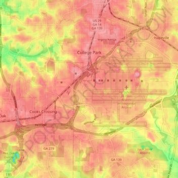
Nombre: Mapa topográfico College Park, altitud, relieve.
Lugar: College Park, Fulton County, Georgia, 30337, United States (33.60420 -84.52475 33.66947 -84.42834)
Altitud media: 298 m
Altitud mínima: 229 m
Altitud máxima: 328 m
Haz una donación
Equípate para tu próxima aventura:
Como asociado de Amazon, este sitio gana comisiones por las compras que califican, sin ningún costo adicional para usted.
Otros mapas topográficos
Haga clic en un mapa para ver su topografía, su altitud y su relieve.
Atlanta
United States > Georgia > Fulton County
Atlanta (/ætˈlæntə/ at-LAN-tə) is the capital and most populous city of the U.S. state of Georgia. It is the seat of Fulton County, the most populous county in Georgia. With a population of 498,715 living within the city limits, it is the eighth most populous city in the Southeast and 38th most populous…
Altitud media: 285 m
Haz una donación
Equípate para tu próxima aventura:
Como asociado de Amazon, este sitio gana comisiones por las compras que califican, sin ningún costo adicional para usted.
Capital City Country Club Lake Dam
United States > Georgia > Fulton County > Atlanta
Altitud media: 294 m
Haz una donación
Equípate para tu próxima aventura:
Como asociado de Amazon, este sitio gana comisiones por las compras que califican, sin ningún costo adicional para usted.
Haz una donación
Equípate para tu próxima aventura:
Como asociado de Amazon, este sitio gana comisiones por las compras que califican, sin ningún costo adicional para usted.
Johns Creek
United States > Georgia > Fulton County > Johns Creek
Johns Creek is located in northeastern Fulton County and is centered at 34°1′44″N 84°11′55″W / 34.02889°N 84.19861°W / 34.02889; -84.19861 (34.0289259, -84.1985790). The elevation ranges from 880 feet (270 m) above sea level along the Chattahoochee River to 1,180 feet (360 m) in the Ocee…
Altitud media: 314 m
Haz una donación
Equípate para tu próxima aventura:
Como asociado de Amazon, este sitio gana comisiones por las compras que califican, sin ningún costo adicional para usted.