
Mapa topográfico Marshall County
Mapa interactivo
Haga clic en el mapa para ver la altitud.
Acerca de este mapa
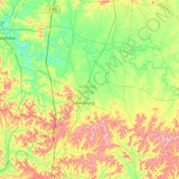
Nombre: Mapa topográfico Marshall County, altitud, relieve.
Lugar: Marshall County, Tennessee, United States of America (35.25262 -86.96093 35.71084 -86.59714)
Altitud media: 244 m
Altitud mínima: 170 m
Altitud máxima: 383 m
Otros mapas topográficos
Haga clic en un mapa para ver su topografía, su altitud y su relieve.
Collinwood
United States of America > Tennessee > Collinwood
Collinwood, Wayne County, Tennessee, 38450, United States of America
Altitud media: 304 m
Laurel Creek
United States of America > Tennessee > Laurel Creek
Bone Cave, Laurel Creek, Van Buren County, Tennessee, 38550, United States of America
Altitud media: 282 m
Murphy Mill
United States of America > Tennessee > Murphy Mill
Cave Spring, Murphy Mill, Claiborne County, Tennessee, 37879, United States of America
Altitud media: 463 m
Parrottsville
United States of America > Tennessee > Parrottsville
Parrottsville, Cocke County, Tennessee, United States of America
Altitud media: 386 m
Mount Juliet
United States of America > Tennessee > Mount Juliet
Mount Juliet, Wilson County, Tennessee, 37122, United States of America
Altitud media: 169 m
Richland
United States of America > Tennessee > Nashville-Davidson > Richland
Richland, Nashville-Davidson, Davidson County, Tennessee, 37209, United States of America
Altitud media: 146 m