
Mapa topográfico Nationaal Park De Groote Peel
Mapa interactivo
Haga clic en el mapa para ver la altitud.
Acerca de este mapa
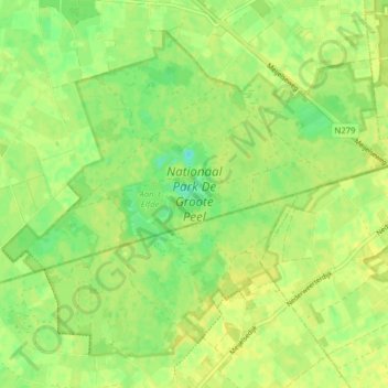
Nombre: Mapa topográfico Nationaal Park De Groote Peel, altitud, relieve.
Altitud media: 29 m
Altitud mínima: 18 m
Altitud máxima: 33 m
Otros mapas topográficos
Haga clic en un mapa para ver su topografía, su altitud y su relieve.
Schoor
Nederland > Limburg > Nederweert > Schoor
Schoor, Nederweert, Limburg, Nederland, 6031, Nederland
Altitud media: 33 m